The Nomads Outdoors Group Inc.
Powered by
Past events
All events
Past events
Apr
24
2022
Past Event
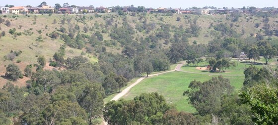
Brimbank Loop Track Walk
Green Gully Reserve Playground
11:30 – 15:30
The Brimbank Park Loop is a 10 km trail located near the airport in Melbourne’s North West, that follows part of the upper Maribyrnong River and Brimbank Park.
GRADE | LENGTH | TYPE: Easy-Medium, approximately 10 km, circuit walk with a total rise of 150m.
ACTIVITY DESCRIPTION: Brimbank Park sits approximately 55 metres below the surrounding western plains. It was first settled by Europeans in the 1830s. The name is thought to have originated from the farmers moving their sheep and cattle 'around the brim of the bank' of the Maribyrnong River.
This is a loop walk starting at Green Gully. The route uses a combination of sealed and well maintained gravel paths. There is one short, but fairly steep climb on the walk (70m), plus the ascent out of the valley at the end.
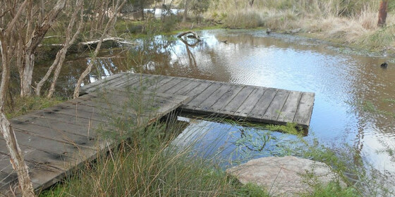
A wetlands area has been extensively revegetated. Birds commonly seen in the park include blue wrens, yellow-tailed thornbills, flame robins, parrots and galahs, and a variety of water birds. Residing in the river red gums are brushtail and ringtail possums. You may see a blue-tongued lizard sunbaking, or catch sight of some swamp wallabies.
The former Dodd farm is of regional historical significance for its association with the original European settlement and farming of the Maribyrnong Valley
Note: Dogs are permitted but must be kept on a lead at all times.
BOOKING: By Thursday 21st April. To register, click on Get Tickets.
Unsure if you've already booked? Click View my bookings.
NOMADS COVIDSAFE CHECKLIST: General Checklist: Nomads walking events.
FURTHER INFORMATION: https://www.visitvictoria.com/regions/melbourne/see-and-do/nature-and-wildlife/national-parks-and-reserves/brimbank-park.
MEETING TIME | LOCATION: 11:30am at the parking area near Green Gully Reserve playground, McCrae Blvd, Keilor Downs, off Green Gully Rd, not the cafe. This is a fairly large parking area, but if sporting events are on, you may have to try surrounding streets.
MAP REFERENCE: Melway map 14 E8 | Google map goo.gl/maps/AxSpZu2M1GWVwELh6.
DISTANCE | TIME FROM GPO: 25 km, approximately 30 minutes to drive.
PUBLIC TRANSPORT: Public transport is possible by train via Sunbury Line to Keilor Plains Station, then Bus #421 (St Albans) to Green Gully Rd/Driscolls Rd, about 50-60 minutes.
FOOD: Carry lunch, snacks and at least 1 litre of water. We will be stopping near the cafe for lunch, if you want to buy something there.
APPAREL | FOOTWEAR: Comfortable walking boots/shoes and dress according to the weather forecast. Much of the walk is exposed, so wear sunblock and hat.
LEADER: Richard C. | Email LeaderRichardC.thenomadsinc@mail.tidyhq.com if you have any questions.
Members can access leader contact details under Members | Leader Contacts when logged in to the website.
HOME BACK TO LIST OF EVENTS MEMBERSHIPS
Apr
23
2022
Past Event
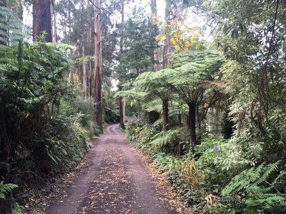
Mt Dandenong Hike - Kalorama to Sassafras via Doongalla Forest
Croydon Railway Station/Railway Grove
09:45 – 17:00
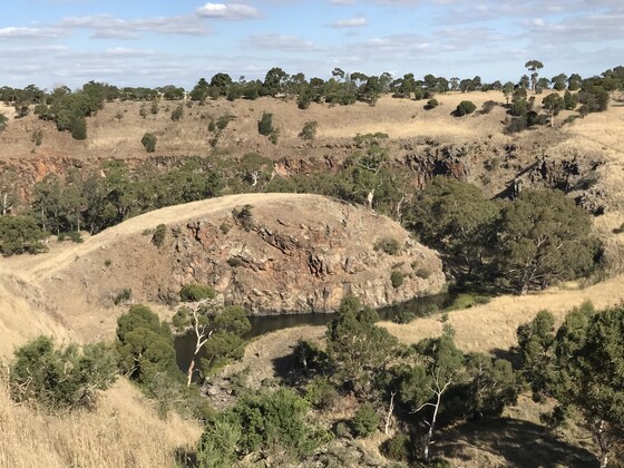
Escape the city and enjoy a full-day spring hike through the picturesque Dandenong Ranges, on what will be a unique event, taking in the lush scenic forest, birds, views of the city, walking tracks, falls and the crisp/fresh air. This event caters for the experienced/ fit hiker who demands a 'real hike' and wants to break out a sweat. This event is graded 'hard to challenging' with a number of steep short inclines throughout.
This is intended to be a public transport friendly event where the start and end points will be accessible by train. There is no carpooling for this event, however, you may organise your own lift with fellow walkers if you wish.
GRADE | LENGTH | TYPE: Hard -> Challenging (in sections), approximately 12.5 km, this event caters for experienced hikers and those with fitness levels that are able to climb short steep tracks. This event is not suitable for first timers or those with limited fitness abilities. If in doubt, contact the leader prior to booking to discuss your fitness levels/suitability for the hike.
ACTIVITY DESCRIPTION:
We will meet at Croydon Station before boarding a bus for our first section of the hike at Kalorama.
Part 1: Kalorama GPO to Five Ways lookout (incline) with a stop at the coffee shop. From here we take a steep incline along the Trig/Kyeema Track and will explore the Kyeema crash site, followed by views near Burke's lookout. Then after a steep descent, we will arrive at Doongalla Picnic Reserve for lunch.
Part 2: From the reserve we will walk through the dense scrub incline along the Dandenong Creek Track and make our way through a steep incline to arrive at Sassafras township. After exploring the township, we will make our way back by bus to Croydon Station.
BOOKING: By Friday 22nd April. To register, click on Get Tickets.
View my bookings (log in required).
NOMADS COVIDSAFE CHECKLIST: Checklist 210606: Mt Dandenong Hike - Kalorama to Olinda Falls via Doongalla Forest.
FURTHER INFORMATION: explorethedandenongs.com.au/western-slopes-trail-mt-dandenong
MEETING TIME | LOCATION: 09:45am at Croydon Train Station, Railway Grove. Exact meetup points will be provided prior to the event by email.
MAP REFERENCE: Melway map 50 grid J3 | Google map goo.gl/maps/LhvezYQ8CpHcSDoy7.
DISTANCE | TIME FROM GPO: 35 km, approximately 35 minutes to drive, 50 minutes by public transport. There is car parking available at the train station for those who wish to drive. We will all take the bus to the starting point regardless of whether you drive to the meeting spot or not. You will need a Myki card for this event and a face mask to ride on public transport.
PUBLIC TRANSPORT: This is a public transport friendly event.
By Train: Take the Lilydale train from Flinders Street and get off at Croydon Station. We will then catch the 688 bus to the starting point as a group. At the conclusion of the walk, the same bus will take us back to Croydon, with a connecting train back to the CBD.
FOOD/DRINKS: Carry lunch, snacks and at least 1-2 litres of water. Also bring sunscreen and a hat, your facemask and hand sanitiser. Bring your Myki card for the return trip by train/bus. We will stop briefly at a coffee shop where you can buy a coffee, and there may be options to purchase food for lunch (although this may be costly). There will also be a late afternoon tea stop in Sassafras at the conclusion of the official hike.
APPAREL | FOOTWEAR: Suitable boots/hiking shoes and dress according to the weather forecast (layering). The mountains are usually a few degrees cooler but you will quickly warm up as you begin the hike! Ensure your shoes are waterproof as some of the paths most likely will be a little wet/muddy and a bit slippery if it has rained heavily prior to the event. Your boots will get some dirt/mud on them!
LEADER: Jason T. | Email LeaderJasonT.thenomadsinc@mail.tidyhq.com if you have any questions.
Members can access leader contact details under Members | Leader Contacts when logged in to the website.
HOME BACK TO LIST OF EVENTS MEMBERSHIPS
Apr
18
2022
Past Event
Easter Monday Cycling: Mernda - Reservoir - Rushall/Fairfield
Mernda Station
10:30 – 16:00
Enjoy an Easter Monday bike ride on the (relatively) new bike paths following the Mernda train line.
GRADE | LENGTH | TYPE: Medium 32.3 km, point-to-point cycling, mostly off-road, with sealed paths and few hills.
ACTIVITY DESCRIPTION: The ride will start at the new Mernda Station. There's a kiosk at the station if you'd like a coffee before heading off. If you are keen for a holiday breakfast, or coffee and cake, to start your day, you can arrive early and make an excursion 1 km up Schotters Rd to the atmospheric Turners Bakery before returning for the start of the ride. From the station we'll follow the new trail down to South Morang Station then Epping Station, after which we'll follow the Darebin Creek Trail south to exit near Dunne St and travel through quiet suburban streets for lunch at the Northside Cafe, 255 Broadway, Reservoir. After lunch we have the choice of making our way to the Northern Pipe Trail (along St Georges Rd) and following that all the way to the Capital City Trail, or of returning to the Darebin Creek Trail and following that back to Fairfield. Either way, there are many options for cycling home or catching a train, as well as a number of train station early exit points along the way.
BOOKING: By Saturday 16th April. To register, click on Get Tickets.
Unsure if you've already booked? Click View my bookings.
NOMADS COVIDSAFE CHECKLIST: General Checklist: Nomads walking events.
MEETING TIME | LOCATION: 10:30am at Mernda Station. The Mernda train that departs from Flinders Street platform 1 at 9:28am arrives at Mernda at 10:29am.
MAP REFERENCE: Google map: goo.gl/maps/A1B52YKqFdN3gHki6
FOOD: Lunch will be purchased at the Northside Cafe. Carry snacks if you wish and a 1 litre of water.
APPAREL | FOOTWEAR: Face mask, helmet and dress according to the weather forecast. A spare tube is recommended.
LEADER: George W. | Email LeaderGeorgeW.thenomadsinc@mail.tidyhq.com if you have any questions.
Members can access leader contact details under Members | Leader Contacts when logged in to the website.
HOME BACK TO LIST OF EVENTS MEMBERSHIPS
Apr
14
2022
Past Event
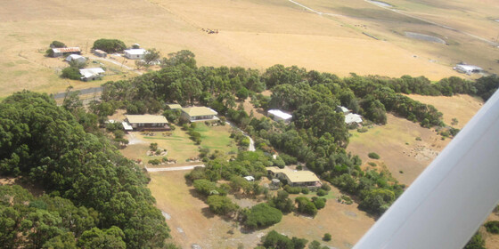
Easter at Yanakie with Wilson Promontory walks
Corner Inlet
14 Apr 2022 10:30 – 18 Apr 2022 16:00
Enjoy the comfort of a home base, together with access to the world class Wilsons Promontory National Park for day walks.
GRADE | LENGTH | TYPE: Easy/Medium – day walks and beach activities.
ACTIVITY DESCRIPTION:
We have a private house at Yanakie overlooking Corner Inlet just outside the park entrance. You can come down for as many days as you like. It is quite flexible. There are many nice day walks in the area. We will decide where to walk each day taking into account the condition of the weather and the participants. The base offers hot showers, comfortable accommodation and a log fire to warm up if the day is cold.
Shower and toilet facilities are available in the house. Camping is available on the property. Bed and floor space is limited in the house, so it will be allocated on a needs basis. Alternatively you can look for accommodation close by, but book early as Easter time is busy.
There is very limited shopping in the area. Bring your own breakfasts and lunches. On Friday night a BBQ is offered. Bring your own meat/veggie burger and anything you like to accompany that. Saturday and Sunday night meals are provided for a small donation.
Roger no longer owns the property, so there is now a small fee of $7 per person, per night (Fri/Sat/Sun) to cover costs. To make things simple it is the same fee whether you camp, or squash into the house. Visitors should take out a Temporary 1 month membership (cost $8) prior to selecting Get Tickets.
BOOKING: By Friday 8th April. To register, click on Get Tickets. There is a limit of 30 people, and it is on a first-booked first-served basis.
Unsure if you've already booked? Click View my bookings.
NOMADS COVIDSAFE CHECKLIST: Checklist 220418 Yanakie/Wilsons Promontory Walks.
FURTHER INFORMATION: www.parks.vic.gov.au/places-to-see/parks/wilsons-promontory-national-park.
MEETING TIME | LOCATION: You can arrive any time from Thursday as arranged with the leader. You will be given location details after registering.
MAP REFERENCE: Melway map X928/628 grid C10 | VicRoads map 103 grid D7 | Google map goo.gl/maps/A8fupz5R28HgD9Ec9. Detailed directions will be provided after the RSVP date.
DISTANCE | TIME FROM GPO: Approximately 195 km. Yanakie is 2.5 hours drive from Melbourne towards Wilsons Promontory.
TRANSPORT: Public transport not available. We will try to maximise car-pooling as parking is limited at the house.
FOOD: Bring supplies for your own breakfast and lunch. Communal night meals will be arranged once the numbers are known. There are staples at the house like sugar, tea etc.
APPAREL | FOOTWEAR: Face mask, hand sanitiser, warm waterproof gear and changes of clothing. Summery attire is also likely to be needed. It might be warm enough to dive into the sea. Light comfortable walking footwear.
ACCOMMODATION: There are a limited number of beds for the early birds, some floor space and plenty of tent space in the garden. Bring linen and towels.
COST: Accommodation charge of $7 per person per night (to be paid when you "Get Tickets"). Free entry to the National Park. Donation towards any meals that are provided.
LEADER: Roger H. | Email LeaderRogerH.thenomadsinc@mail.tidyhq.com if you have any questions.
Members can access leader contact details under Members | Leader Contacts when logged in to the website.
HOME BACK TO LIST OF EVENTS MEMBERSHIPS
Apr
10
2022
Past Event
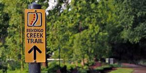
Bendigo Creek Trail - Kangaroo Flat to Bendigo
Bendigo
09:00 – 19:24
Enjoy a walk along the Bendigo Creek Trail and parklands.
GRADE | LENGTH | TYPE: Moderate, approximately 12 km, point-to-point walk on flat paths.
ACTIVITY DESCRIPTION: We'll head off to Kangaroo Flat (Bendigo) by train, car travel optional. After arriving we walk briefly through the Kangaroo Flat Botanical Gardens (native bushland) to Crusoe Reservoir, then backtracking slightly, we continue along the Bendigo Creek Trail past the Kangaroo Flat Bushland Reserve. Depending on time, we will stop for refreshments before catching the train home.
BOOKING: By Friday 8th April. To register, click on Get Tickets.
Unsure if you've already booked? Click View my bookings.
NOMADS COVIDSAFE CHECKLIST: General Checklist: Nomads walking events.
FURTHER INFORMATION: vline.com.au.
MEETING TIME | LOCATION: 9am at Southern Cross Station, in the front car of the Echuca train (unreserved). Check monitors for platform. The Echuca train departs at 9:06am.
MAP REFERENCE:
Southern Cross Station: Melway map 1A grid A7 | Google map goo.gl/maps/LAmusKZNy8A69YfZ9.
Kangaroo Flat Station: Melway map X921 grid D9 | Google map goo.gl/maps/uX1vncfMwvULvUXz9.
DISTANCE | TIME FROM GPO: 146 km, approximately 1 hour 41 minutes to drive, around 2 hours by train.
PUBLIC TRANSPORT: Depart Southern Cross at 09:06am on the Echuca train. Arrive Kangaroo Flat at 10:50am. Picks up at Footscray at 09:13am and Sunbury at 09:35am. Return trains depart Bendigo at 4:26pm, 5:26pm, 7:02pm. Arrives Southern Cross 6:24pm, 7:24pm, 9:12pm.
Cost: Return Train Travel, Myki Weekend Cap: Full $48.16; Concession $24.08; or Free Travel Voucher. (Includes Suburban Travel).
FOOD: Carry lunch, snacks and at least 1 litre of water.
APPAREL | FOOTWEAR: Comfortable walking boots/shoes and dress according to the weather forecast.
LEADER: Paul K. | Email LeaderPaulK.thenomadsinc@mail.tidyhq.com if you have any questions.
Members can access leader contact details under Members | Leader Contacts when logged in to the website.
HOME BACK TO LIST OF EVENTS MEMBERSHIPS
Apr
05
2022
Past Event
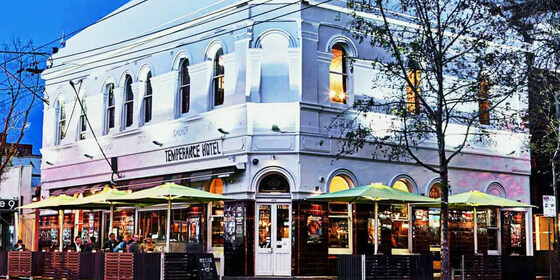
Winter Planning & Social Night - Temperance Hotel
426 Chapel St
19:00 – 21:00
Our quarterly planning night, in conjunction with the regular monthly social night - this month at the Temperance Hotel.
GRADE: Social.
ACTIVITY DESCRIPTION: The Nomads hold a social night each month, where members and guests can enjoy a meal, talk about upcoming events, compare notes on past activities and float ideas on events they would like to see run. At the quarterly planning meetings, in addition to the monthly social activities the draft program, which will have been prepared via Zoom the previous night, is presented so attendees can make suggestions or fill in any gaps. Do you want to see more of a particular activity, or do you have a particularly favourite area of Victoria you would like to share with others? Do you have an idea for something apart from the regular walks? We'd love to hear from you. Everyone is welcome – you don't have to volunteer for an activity. New members are especially invited to this meeting as an orientation to Nomads activities.
BOOKING: By Monday 4th April. To register, click on Get Tickets.
Unsure what you've booked for? Click View my bookings.
MEETING TIME | LOCATION: 7pm at the Temperance Hotel, 426 Chapel St, South Yarra.
MAP REFERENCE: Melway map 2L grid J8. Google map goo.gl/maps/8jh5oWmraU2Vn1BE6.
PUBLIC TRANSPORT and PARKING: The Temperance Hotel is well served by public transport, but parking is limited. Suggested options:
Tram 72 to stop 30 (Prahran Market / Commercial Rd)
Tram 6 to stop 30 (Prahran Station / High St)
Tram 58 to stop 128 (Chapel St / Toorak Rd)
Tram 78 to stop 48 (Wilson St / Chapel St)
Train: Cranbourne, Pakenham, Frankston or Sandringham line to South Yarra
LEADER: Garry O. | Email LeaderGarryO.thenomadsinc@mail.tidyhq.com if you have any questions.
Members can access leader contact details under Members | Leader Contacts when logged in to the website.
HOME BACK TO LIST OF EVENTS MEMBERSHIPS

Apr
04
2022
Past Event
Winter Program Pre-planning - Online via Zoom
19:00 – 20:00
Preparing the draft Winter program - online via Zoom.
GRADE: Social.
ACTIVITY DESCRIPTION:
The bulk of the planning for the Winter program will be done in this pre-planning meeting via Zoom in readiness to present the draft program the next night at the Social Evening, where attendees will be invited to provide additional suggestions and help fill any gaps.
BOOKING: By 5pm Monday 4th April. To register, click on Get Tickets. Alternatively, simply click on the Zoom link in the reminder email sent to members a few days prior to the event.
Unsure what you've booked for? Click View my bookings.
DRAFT PROGRAM: Nomads Draft Program.
MEETING TIME | LOCATION: 7pm online via Zoom. Those who registered will be sent the Zoom link by 6pm on Monday evening.
LEADER: Garry O. | Email LeaderGarryO.thenomadsinc@mail.tidyhq.com if you have any questions.
Members can access leader contact details under Members | Leader Contacts when logged in to the website.
Photo by Bich Tran from Pexels.
HOME BACK TO LIST OF EVENTS MEMBERSHIPS
Apr
02
2022
Past Event
Mixed naturist bushwalk near Lancefield, optional BBQ & overnight
Lancefield
02 Apr 2022 10:00 – 03 Apr 2022 16:00
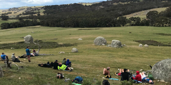
A naturist walk of medium difficulty through two farms in the spectacular granite boulder country north of Lancefield. A picturesque creek, some untouched forest and great views from two of the nearby rocky hills. This walk will be a different route from what we've done before.
To relax after the event we are endeavouring to hire a spa. (To cover the cost for this we have needed to raise the cost of some of the tickets for this event. We hope you like it and that it is worthwhile.)
GRADE | LENGTH | TYPE: Medium 6 km naturist circuit walk. There is some easy walking through grassy paddocks, but a bit more effort will be required to walk up the farm hills for a view. We will also pass through an open forest and down a 4WD track for great views of the farmland below.
ACTIVITY DESCRIPTION:
SATURDAY WALK: This walk is for naturists. We will meet and unload the cars at the overnight farmhouse anytime between 10am and 10:30am. Hot drinks and nibbles will be available until 11am. We will then take some of the cars 3 km to a neighbouring property. From there we plan to get ourselves comfortably unattired and start our walk through the deserted open paddocks and over to some hills for the views. We will then circle around through the boulder-strewn forest and down a 4WD track for inspiring views of the valley below. Lunch will be eaten at a good spot along the way when we get hungry. If the day is hot we can have a nude swim in a farm dam or a waterhole in Mollison Creek. Following this we plan to head back to the overnight farmhouse for drinks and snacks at around 4pm. The spa should be operating by then with the BBQ to follow around 6pm.
OVERNIGHT: Optional evening BBQ, overnight, breakfast and lunch at the farmhouse. After the walk we have been invited back for further naturist socialising at the very comfortable farmhouse with its great open fire.
SLEEPING: For those staying overnight, there are two made-up queen size beds. Other people can sleep on the carpeted floor in the library or the lounge room - please BYO sleeping bag, sleeping mat/lilo, pillow etc. There is one spare doona, a few sleeping bags and a couple of spare foam sleeping mats at the property. Or if you like, you can put up your tent on the back lawn. There is also room for campervans etc.
BBQ: BYO meat and drinks. Basic salads and bread will be supplied. A few desserts and other snacks would be appreciated.
TOWELS: Please BYO towels for sitting on and for a shower.
BREAKFAST: Breakfast is supplied, including eggs and bacon, and for Sunday lunch there are always plenty of leftovers from the night before.
OTHER OPTIONS: For those who would like to have a look around the very picturesque scenery at the overnight farm on the Sunday morning, we plan to do a short naturist walk of about 1.5 to 2 hours along Mollison Creek, or to the gorge, or to the host's back paddocks. This will be followed by lunch to eat up the spare food.
BOOKING: By Wednesday 30th March. To register, click on Get Tickets. One ticket covers all activities you may wish to participate in - walk, BBQ and/or overnight.
RSVP FOR OVERNIGHT ACCOMMODATION: If you wish to stay overnight, you will need to SEND AN EMAIL to Colin, our farmhouse host, on LeaderColinP.thenomadsinc@mail.tidyhq.com to book your accommodation. Please state what accommodation you would like - bed, floor, tent or campervan. Please also include a contact phone number.
Sleeping places in the house are limited to 18.
The number of people attending the event is limited to 23 so that we can all sit down to eat inside the house.
There is no limit on tents and campervans.
Unsure if you've already booked? Click View my bookings.
NOMADS COVIDSAFE CHECKLIST: General Checklist: Nomads walking events.
COST: There are four ticket types available for this event. Please choose the ticket that best suits your wishes.
1. Walk, overnight, spa: Nomads members $25 | Non-members $30
2. Walk overnight, no spa: Nomads members $5 | Non-members $10
3. Walk and spa: Nomads members $20 | Non-members $25
4. Walk only: Nomads members $0 | Non-members $5
The increased cost for some tickets is to cover the cost of a spa we are endeavouring to hire. If we are unsuccessful, all participants who have paid for the spa will be refunded $20.
MEETING TIME | LOCATION: Any time between 10am and 10.30am at a farmhouse 15 km north of Lancefield. The exact address will be sent to those who have purchased a ticket by 10am on Thursday 31st March. We plan to drive 3 km to the start of the walk at about 11am.
Tea, coffee and snacks will be provided at the farmhouse. If you'd like egg and bacon sandwiches/rolls and a latte etc beforehand, the best place to get these would be from a cafe in the towns of Romsey or Lancefield.
MAP REFERENCE: Melway map X909/609 grid J7 | Google Map: goo.gl/maps/5tjy71DBz9waYR9a6.
DISTANCE | TIME FROM GPO: 87 km and 1 hour 15 minutes from the GPO. The farm and the town of Lancefield are due north of Tullamarine Airport.
PUBLIC TRANSPORT: Catch the 7:48am Metro train from Southern Cross to Sunbury station arriving at 8:32am. At Sunbury catch the 9am regional bus to Lancefield, arriving 9.33am at the corner of High St and Main Rd. From there we will need to arrange a ride to the farm for you. It probably would be easier for you to email the leader, Russell, on LeaderRussellW.thenomadsinc@mail.tidyhq.com to see if he can arrange a lift for you from Melbourne.
FOOD: Carry lunch, snacks and water for the Saturday naturist walk.
APPAREL | FOOTWEAR: Sunscreen, hat and sunglasses. Wear comfortable walking shoes/boots. A small towel to dry off after a swim in the farm dam or creek swimming hole if it's warm enough.
LEADER: Russell W. | Email LeaderRussellW.thenomadsinc@mail.tidyhq.com if you have any questions.
Members can access leader contact details under Members | Leader Contacts when logged in to the website.
HOME BACK TO LIST OF EVENTS MEMBERSHIPS
Mar
27
2022
Past Event
Great Victorian Rail Trail - Part 9
Mansfield Visitor Information Centre
09:50 – 16:30
Join in on the final leg of the GVRT from Bonnie Doon to Mansfield.
GRADE | LENGTH | TYPE: Moderate (due to distance), 19 km point-to-point walk on a formed track.
ACTIVITY DESCRIPTION: After meeting in Mansfield at the Visitor Information Centre, at 09:50am, we will carpool to the Bonnie Doon Hotel and then commence the final leg of the rail trail to Mansfield. The trail follows close to the highway most of the way. On arrival at Mansfield, it will complete the 134 km (plus some) walk from Tallarook via Alexandra. Note: We will not be viewing or crossing the rail bridge across Lake Eildon, as this adds another 2 km to the walk. This could be done on the return drive home. We will stop for refreshments before heading home.
BOOKING: By Friday 25th March. To register, click on Get Tickets.
Unsure if you've already booked? Click View my bookings.
NOMADS COVIDSAFE CHECKLIST: General Checklist: Nomads walking events.
FURTHER INFORMATION: www.greatvictorianrailtrail.com.au.
MEETING TIME | LOCATION: 09:50am for a 10:00am SHARP departure, at the Mansfield Visitor Information Centre, 175 High Street, Mansfield. (Maroondah Highway, former Mansfield Railway Station site).
MAP REFERENCE: Melway map X907 grid K8 | Google map: https://goo.gl/maps/ZQwuxwMDMKBfPTBa6.
DISTANCE | TIME FROM GPO: 190 km, approximately 2 hours 34 minutes to drive via Lilydale or 212 km, 2 hours 36 minutes via Hume Fwy.
PUBLIC TRANSPORT: V/Line bus:
Melbourne to Mansfield (Saturday): departs 08:30am and 6:00pm - Arrives 11:50am and 8:55pm. Requires an overnight stay, own arrangement.
Mansfield to Melbourne (Sunday): departs 6:00pm - arrives 9:05pm.
FOOD: Carry lunch, snacks and at least 1 - 2 litres of water.
APPAREL | FOOTWEAR: Comfortable walking boots/shoes and dress according to the weather forecast.
LEADER: Paul K. | Email LeaderPaulK.thenomadsinc@mail.tidyhq.com if you have any questions.
Members can access leader contact details under Members | Leader Contacts when logged in to the website.
HOME BACK TO LIST OF EVENTS MEMBERSHIPS
Mar
20
2022
Past Event
The Briars Park and Balcombe Creek Walk - Mount Martha
The Briars Park
11:00 – 17:00
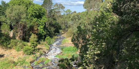
Discover two lesser known gems of the Mornington Peninsula with this scenic walk through The Briars Park Wildlife Sanctuary and Balcombe Creek Estuary Boardwalk.
GRADE | LENGTH | TYPE: An easy 12 km point-to-point walk.
ACTIVITY DESCRIPTION: The meeting point for this walk is on Craigie Road, Mount Martha about 100 metres east of the roundabout junction with Dunns Road, Mount Martha. If you are driving from Melbourne via the Nepean Highway, take the Craigie Road exit on the left and drive through the roundabout at the Dunns Road intersection. If you are driving via the Peninsula Link and Moorooduc Highway, take the Craigie Road exit. As there is only limited parking on Craigie Road and as this is a point-to-point walk, we will do a car shuffle leaving most of the vehicles at Mount Martha village.
We will take a track through a bushland reserve to reach The Briars Park. Before entering the park we will walk to the old farm and take in the views. The farm holds a restaurant (now closed), old farm equipment and a nursery which had an unusual connection to Napoleon. We will then walk through the park's wildlife sanctuary. After that we will return to the park’s visitor centre where there is a choice of undercover or outdoor picnic tables for our lunch break. You can also buy a coffee. After lunch we'll then head through to the Mount Martha township on the Balcombe Creek Estuary Boardwalk. A coffee or a drink in the village will be an optional extra at the end of the walk before we do a car shuffle back to pick up the other vehicles.
BOOKING: By Friday 18th March. To register, click on Get Tickets.
Unsure if you've already booked? Click View my bookings.
NOMADS COVIDSAFE CHECKLIST: Checklist 220320: The Briars Park and Balcombe Creek Walk - Mount Martha.
FURTHER INFORMATION: The Visit Mornington Peninsula website has further information about The Briars Park Walking Trails and Balcombe Creek Estuary Boardwalk.
MEETING TIME | LOCATION: 11am on Craigie Road, 200 metres south-east of the junction between Craigie Road and Dunns Road, Mount Martha.
MAP REFERENCE: Melway map 145 grid F9 | Google map goo.gl/maps/8pshS4cCdoqSzE3Q8.
DISTANCE / TIME FROM GPO: Allow 1 hour 15 mins from Melburne CBD.
PUBLIC TRANSPORT: The Frankston train that departs from Flinders Street Station platform 8 at 8:57am arrives at Frankston Station at 10:04am. Transfer to the #788 bus that departs from Bay F at 10:09am. The bus arrives at the corner of Craigie Rd & Nepean Highway at 10:39am. From there, walk east along Craigie Rd to the meeting point, 200m past Dunns Rd.
FOOD: Carry lunch, snacks and water for your needs throughout the day.
APPAREL | FOOTWEAR: Wear comfortable walking boots/shoes and dress to meet the forecast weather conditions.
LEADER: Cahal F. | Email LeaderCahalF.thenomadsinc@mail.tidyhq.com if you have any questions.
Members can access leader contact details under Members | Leader Contacts when logged in to the website.
HOME BACK TO LIST OF EVENTS MEMBERSHIPS
Mar
20
2022
Past Event
Mixed Naturist Walk at Deep Creek Chintin
84 High St
10:15 – 16:00
An easy to medium naturist walk through a remote, spectacular gorge north of Melbourne. We will stop for a relaxed lunch and swimming breaks at some great waterholes.
GRADE | LENGTH | TYPE: An easy to medium walk including a couple of moderate climbs. It is approximately 6 km in length. For quite a bit of the walk there is a small track through the gorge. At other times we are stepping across bluestone river rocks. The walk to the top of the valley is a rarely used 4WD track and along the top of the escarpment is quite a nice kangaroo pad. Approximately 3 hours walking time plus 1.25 hrs lunch and swim stops.
ACTIVITY DESCRIPTION: This walk is for naturists. Stroll down to the valley of Deep Creek and view the spectacular rock walls along the side of this valley. It is in an unexpectedly remote area of the countryside and appears not to have been visited by anyone for a very long time. The waterholes are wonderful, deep with crystal clear water and they appear to last well until the end of summer! Deep Creek is one of the main tributaries to the Maribyrnong River. Along the river course are beautifully large and shady river red gums. Enjoy the atmosphere in this relatively unknown ravine. A good chance you'll see a kangaroo or two as well. Back at the cars by 4pm approx. The cars will be parked in Kennedy's Lane, close to Chintin Rd, Chintin. This spot is 20 minutes (18 km) from Wallan.
BOOKING: By Sunday 20th March. To register, click on Get Tickets.
Unsure if you've already booked? Click View my bookings.
NOMADS COVIDSAFE CHECKLIST: Checklist 220320: Walk at Deep Creek, Chintin.
MEETING TIME | LOCATION: 10:15am for morning coffee and catch up at Pretty Sally Bakehouse, 84 High St, Wallan (mask & double vaxxed required to enter). This is the single storey brick building next to Hogan's Hotel (and is on the Melbourne side of the hotel). Entry to the carpark behind the Bakehouse, is between Hogan's Hotel and the Bakehouse.
10.40am in the rear carpark for the day's briefing and car transport arrangements. If you'd like something to eat at the bakehouse you will need to arrive well before 10.00am. The cafe only seats about 40 people and when we all arrive the service will be very slow.
MAP REFERENCE: Melway map 646 grid A10 | VicRoads map 60 grid H8 and map 638 grid D8 | Google map: https://goo.gl/maps/eUm6vi6G5kUaUdq86
DISTANCE | TIME FROM GPO: 60 km, 1 hour.
PUBLIC TRANSPORT: At this stage I can't find any suitable public transport arriving in time on Sunday morning. We may be able to arrange a lift for you from a train station in the Metro area. Please email Russell on LeaderRussellW.thenomadsinc@mail.tidyhq.com if you would like a lift. Transport back to Melbourne should be no problem as many cars are coming back at various times.
APPAREL | FOOTWEAR: Face mask (& double vaxxed to enter the bakehouse). Sunscreen, hat, dark glasses, comfortable walking boots/shoes, towel to dry off after swimming/paddling. Shorts etc. will be required when we walk from the cars 1/2 km to the gorge.
FOOD: Carry lunch and snacks. Most people take at least 600ml to 1 litre of water, though some people need more, especially if hot.
COST: Nomads financial members free, non-financial members $5.
LEADER: Russell W. | Email LeaderRussellW.thenomadsinc@mail.tidyhq.com if you have any questions.
Members can access leader contact details under Members | Leader Contacts when logged in to the website.
HOME BACK TO LIST OF EVENTS MEMBERSHIPS
Mar
19
2022
Past Event
Alphington to Bundoora Ramble
Alphington Station
10:30 – 15:30
Enjoy a relaxing stroll beside the picturesque Darebin Creek. Travel via public transport is possible.
GRADE | LENGTH | TYPE: Moderate, approximately 12 km, point-to-point walk on mainly flat paths with public transport connections.
ACTIVITY DESCRIPTION: Catch a Hurstbridge line train from Flinders St, meeting at 10:06am at a leafy Alphington Station (I'll be there to greet and quick takeaway coffee option across the road), or 10:26am, for a 10:30am start to ramble, walking a circuit around greater Alphington Park, before following the Darebin Trail upstream, avoiding cycleways as much as possible, stopping (around midday) on a lawn area for BYO lunch adjacent to Northlands (food options available from the mall's food court inside) but we move on sharp at 12:45pm, back on streamside tracks upstream, passing under Plenty Rd (1:30pm), and following the trail with a mixture of urban and rural vistas, into Bundoora Parklands concluding the walk at the Bundoora Park Farm Cafe at approximately 3pm for well earned refreshments before catching a homeward bound tram in nearby Plenty Road. Optional short walk uphill, to look at the original farm property Homestead before catching the tram back in the direction of the city.
BOOKING: By Thursday 17th March. To register, click on Get Tickets.
Unsure if you've already booked? Click View my bookings.
NOMADS COVIDSAFE CHECKLIST: Checklist 220319: Alphington to Bundoora Ramble.
MEETING TIME | LOCATION: 10:06am at the Alphington Railway Station for a 10:30am departure.
MAP REFERENCE: Melway map 31 grid C10 | Google map goo.gl/maps/6t4kLP8W9HKnaxFJ8.
PUBLIC TRANSPORT: The Hurstbridge line train that departs Flinders Street Station platform 1 at 9:38am arrives at Alphington Station 10:06am with time for a swift and optional takeway coffee across the road (9:58am for a 10:26am arrival for those not wanting one). However, we aim to leave Alphington 10:30am sharp, to keep to programme.
FOOD: Carry lunch, snacks and at least a litre of water if weather is hot.
APPAREL | FOOTWEAR: Comfortable walking boots/shoes and dress according to the weather forecast.
LEADER: Michael C. | Email LeaderMichaelC.thenomadsinc@mail.tidyhq.com if you have any questions.
Members can access leader contact details under Members | Leader Contacts when logged in to the website.
HOME BACK TO LIST OF EVENTS MEMBERSHIPS