The Nomads Outdoors Group Inc.
Powered by
Past events
All events
Past events
Dec
20
2020
Past Event
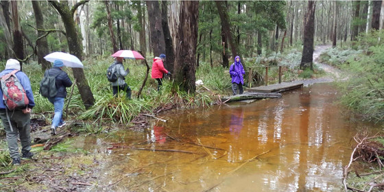
Trentham-Lyonville circuit walk *20 Dec*
Trentham Railway Station & Visitor Information Centre
11:00 – 16:00
A leisurely, scenic walk in the goldfields region, taking in a little history and some great country culinary offerings (COVID-19 permitting).
GRADE | LENGTH | TYPE: Easy, 13 km circuit walk that hopefully will include lunch at the Radio Springs Hotel, 1 High St, Lyonville.
ACTIVITY DESCRIPTION:
Starting at the former Trentham Railway Station (now a museum), we will follow The Domino Rail Trail (part of the original railway from Daylesford to Carlsruhe) to Lyonville for lunch. After lunch we will return via The Domino Trail, with a small diversion, back to Trentham. Afternoon tea will be taken in the RedBeard Historic Bakery for those still hungry.
BOOKING: By Saturday 5th December if you wish to have lunch at the Radio Springs Hotel (bookings can be made for the walk up until Thursday 17th December, but in that case you would need to BYO lunch to have lunch within the Lyonville hamlet). To register, click on Get Tickets.
MEETING TIME | LOCATION: 11am at the car park next to the Trentham Railway Station, Victoria St, Trentham.
MAP REFERENCE: Melway map X909 grid E10 | Google map goo.gl/maps/ihriH1C764TTSeCc8.
DISTANCE | TIME FROM GPO: 95 km, 1 hour and 30 minutes.
LUNCH: The Leader will arrange for those participants who wish to do so to have lunch at the Radio Springs Hotel in Lyonville. This requires an advance booking be made. Therefore all participants who wish to have lunch at the hotel must register by 5th December. The day before the walk the leader will confirm the booking arrangements with all participants. The Radio Springs Hotel menu can be viewed on the website. Main courses range from $24 to $35, or there is also a Thai menu that is quite a bit cheaper. Members who do not wish to lunch at the hotel can BYO their own food and beverage and find a suitable rest spot within the Lyonville Hamlet.
APPAREL | FOOTWEAR: Suitable boots are recommended, as the ground may be wet/damp. Layered clothing as this is an event in the high country that can see low temperatures in the open and warm inside the hotel.
LEADER: Cahal F. | Email the Leader if you have any questions. Members can access leader contact details under Members | Leader Contacts when logged in to the website.
HOME BACK TO LIST OF EVENTS MEMBERSHIPS
Dec
12
2020
Past Event
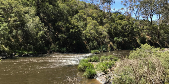
John Cummins Reserve Walk, Yea
Yea Riverside Caravan Park
11:00 – 15:00
An easy walk of part of the Yea Wetlands, including the John Cummins Reserve, in conjunction with the Tallarook to Alexandra cycling weekend.
GRADE | LENGTH | TYPE: Easy, approximately 8 - 10 km, circuit walk. An easy, short walk is also planned for Sunday morning.
ACTIVITY DESCRIPTION:
For this trip we will be joining the cyclists on the Tallarook to Alexandra cycling weekend. Over the past 10 years, the Yea Wetlands have been transformed from an inaccessible floodplain wetland to become one of Yea’s best kept secrets. Just a short walk from High Street you can lose yourself in the peace and tranquility of the natural bush and riverine floodplain wetlands.
BOOKING: By Thursday 10th December. The accommodation option has now booked out.
To register for the walk(s), click on Get Tickets.
ACCOMMODATION BOOKED OUT: If you are planning to stay at the Yea accommodation, you must also book accommodation via Get Tickets in the Tallarook to Alexandra cycling weekend event, selecting "Walking" as your Preferred Activity.
FURTHER INFORMATION: www.ywatercentre.com.au/the-wetlands
MEETING TIME | LOCATION: 11am at the Yea Riverside Caravan Park, 1 Court St, Yea.
MAP REFERENCE: Melway map X910 grid Q8 | Google map goo.gl/maps/u8cnJnZnAJDEFPBXA.
DISTANCE | TIME FROM GPO: 110 km, 1 hour 45 minutes, by car from Melbourne.
PUBLIC TRANSPORT: It’s not feasible to take public transport if you wish to do the day trip only. There is a bus from Southern Cross Station on Friday night if you wish to stay the two nights in Yea.
ACCOMMODATION: Two well appointed 2-bedroom villas have been reserved at Yea Riverside Caravan Park at 1 Court St, Yea. Each villa can accommodate six persons as they comprise one bedroom having four bunk beds and the other having a single queen bed. The villas have their own shower and toilet. They also have air conditioning, TV, kitchen and dining amenities. Towels and linen are supplied. The park also has communal showers and toilets that can be used. Check it out at yeariverside.com.au/accommodation/2-bedroom-villas.
Price per bunk space: $68 for the 2 nights, assuming cabins fully booked
Price per private room with queen size bed: $136 for the 2 nights, assuming cabins fully booked (maximum of two rooms available. Two persons can share the private rooms for $34 each per night, which would optimise beds for 6 persons per cabin per night).
Accommodation Provisos:
If not fully booked, there may be a surcharge of at most $16 per bunk space per night (or $32 per private room per night).
If the event needs to be cancelled due to COVID-19 regulations, any payments made would be fully refunded.
APPAREL | FOOTWEAR: Comfortable walking boots/shoes and dress according to the weather forecast.
LEADER: Richard C. | Email the Leader if you have any questions. Members can access leader contact details under Members | Leader Contacts when logged in to the website.
Image: VisitVictoria.com
HOME BACK TO LIST OF EVENTS MEMBERSHIPS
Dec
11
2020
Past Event
Cycling Tallarook to Alexandra - 2 Overnights in Yea
Southern Cross Station
11 Dec 2020 08:25 – 13 Dec 2020 17:30
A three day cycling circuit of part of the Great Victorian Rail Trail, incorporating the Cheviot Tunnel and lunch in Alexandra, with both nights spent in the picturesque town of Yea.
** The accommodation options are now booked out, but you can still attend the event if you can organise your own accommodation (or you can just attend the Yea - Alexandra - Yea cycling circuit on Saturday) **
GRADE | LENGTH | TYPE: Hard grade 154 km cycling circuits with public transport access.
Friday and Sunday are graded Medium, with a distance of 40 km each day.
Saturday is graded Hard, due to both the distance (74 km) and some hills, though the hills are relatively small, you’ll only be carrying what’s needed during the day and the whole day will be available for the cycling.
ACTIVITY DESCRIPTION:
This is a three day cycling circuit of part of the Great Victorian Rail Trail, with both nights spent in the picturesque town of Yea. It will not be a race or a test of endurance. We will look after each other and stick together. Saturday’s ride is particularly picturesque, with lunch in the beautiful town of Alexandra.
Friday: 40 km: train to Tallarook departing 8:25am + cycle Tallarook to Yea (Friday night in Yea)
Saturday: 74 km: cycle from Yea to Alexandra via Cathkin, and back to Yea (Saturday night in Yea)
Sunday: 40 km: cycle from Yea to Tallarook + 4:15pm depart by train back to Melbourne arriving 5:27pm.
BOOKING: By Wednesday 9th November. To register, click on Get Tickets. This event is for Nomads members only, but visitors can take out a Temporary 1-month membership (cost $8) then make their booking
FURTHER INFORMATION: Great Victorian Rail Trail: www.greatvictorianrailtrail.com.au.
MEETING TIME | LOCATION: Before 8am for an 8:25am departure from Southern Cross Station. The Seymour train that departs Southern Cross at 8:25am arrives in Tallarook at 9:53am.
MAP REFERENCE: Southern Cross Station: Melway map 2E grid K6 | Google map goo.gl/maps/ekQKfLrhCcy.
DISTANCE | TIME FROM GPO: 1 hour 26 minute train journey from Southern Cross Station.
FOOD: Bring snacks if required and a water bottle - there are some water refill points along the way. We will be utilising modest cafes, bakeries or pubs for meals when and where possible. You will need money for this.
APPAREL | FOOTWEAR: Bring suitable bike attire to match the weather forecast, and to cater for all possible contingencies. Be sure to bring at least one spare tube and ensure your bike is in good working order. Bring something suitable to wear in the evenings, and perhaps for the return train trip (for the wellbeing of your fellow travellers)! Bring minimal personal effects for the trip as you will have to carry everything with you on your bike.
ACCOMMODATION: Two well appointed 2-bedroom villas have been reserved at Yea Riverside Caravan Park at 1 Court St, Yea. Each villa can accommodate six persons as they comprise one bedroom having four bunk beds and the other having a single queen bed. The villas have their own shower and toilet. They also have air conditioning, TV, kitchen and dining amenities. Towels and linen are supplied. The park also has communal showers and toilets that can be used. Check it out at yeariverside.com.au/accommodation/2-bedroom-villas.
Price per bunk space: $68 for the 2 nights, assuming cabins fully booked
Price per private room with queen size bed: $136 for the 2 nights, assuming cabins fully booked (maximum of two rooms available. Two persons can share the private rooms for $34 each per night which would optimise beds for 6 persons per cabin per night).
Accommodation Provisos:
If not fully booked, there may be a surcharge of at most $16 per bunk space per night (or $32 per private room per night).
Two cabins have been booked. If we need to cancel one cabin (very unlikely), the last people registered may miss out on accommodation.
If the event needs to be cancelled due to COVID-19 regulations, any payments made would be fully refunded.
Researched in mid August 2020, additional accommodation can be arranged by directly contacting Yea Riverside Caravan Park Ph 5797 2972 - they have queen bed studio suites at $125 per night, or close by at Tartan Motel Ph 5797 2202 for a one person per bedroom at $95 a night, or 2 persons in one bed per room $110 per night or 2 persons in separate beds for $120 per night. These places are not far from Yea Riverside Caravan Park. There are other places too, and most also offer “family rooms”, but it would be wise to book direct ASAP.
LEADER: Kevin K. | Email the Leader if you have any questions. Members can access leader contact details under Members | Leader Contacts when logged in to the website.
HOME BACK TO LIST OF EVENTS MEMBERSHIPS
Dec
06
2020
Past Event
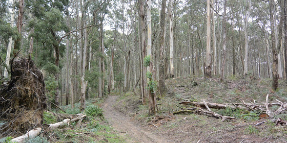
Babbington Hill Walk, Lyonville ** 6 Dec **
Tram Street & C317
11:00 – 16:00
A climb to the top of Babbington Hill in the Wombat State Forest, passing by a hidden reservoir and an historic mineral spring.
GRADE | LENGTH | TYPE: Moderate 9.7 km circuit walk.
ACTIVITY DESCRIPTION:
This scenic walk highlights some of the interesting history of Lyonville, located in the Daylesford Spa Country. The farmlands at the start quickly give way to the densely treed Wombat State Forest, which is what originally attracted James Lyon, after whom the town is named, to build large saw mills in the region. We pass by, and hopefully around, the Bullarto Reservoir then climb Babbington Hill (822m) before descending to the historic Lyonville Spring to taste its waters. The walk will end at the starting point, but attendees will then be invited to go to the nearby Radio (Radium) Springs Hotel, once owned by Ernie Sigley, that will hopefully be able to welcome us for after-walk refreshments and a little more history. If it's not open, a plan B will ensure you get some refreshments prior to heading back home.
BOOKING: By Thursday 3rd December. Click on Get Tickets to register.
FURTHER INFORMATION: Bushwalking Victoria: Babbington Hill Wombat State Forest.
MEETING TIME | LOCATION: 11am on the corner of Tram St and the C137 Daylesford-Trentham Rd.
MAP REFERENCE: Melway map X909 grid D10 | Google map goo.gl/maps/AcrfAxJF7GPZj8Pt6.
DISTANCE | TIME FROM GPO: 102 km, approximately 1 hour 15 minutes via Calder Fwy/M79 to Woodend, then follow directions to Daylesford, taking the Tylden-Woodend Rd, then the C318 Kyneton-Trentham Rd, and finally the C317 Trentham-Daylesford Rd to Lyonville.
PUBLIC TRANSPORT: Take the 9:02am Echuca train from Southern Cross to Woodend, then transfer to the Daylesford coach service, arriving at Main St/Daylesford-Trentham Rd, Lyonville at 10:46am.
FOOD: Carry lunch, snacks and a litre of water.
APPAREL | FOOTWEAR: Comfortable walking boots/shoes and dress according to the weather forecast. Lyonville can be several degrees cooler than Melbourne.
LEADER: Robert H. | Email the Leader if you have any questions.
Members can access leader contact details under Members | Leader Contacts when logged in to the website.
All bookings must be made via GET TICKETS on the Nomads TidyHQ website. Visitors, including Meetup Members, need to pay a $5 fee per event, (or an $8 one month Temporary Membership) except where shown as a free event.
HOME BACK TO LIST OF EVENTS MEMBERSHIPS
Dec
01
2020
Past Event
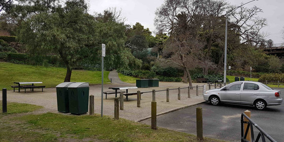
Annual Pre-Christmas BBQ
Yarra Bank Reserve
18:30 – 21:00
Join us for the popular annual Christmas BBQ beside the Yarra River in a tranquil, little-known park in Hawthorn.
GRADE: Social.
ACTIVITY DESCRIPTION:
Join your friends on the banks of the Yarra River at Hawthorn for a pre-Christmas BBQ in lieu of our monthly indoors social evening. The venue is a secluded spot that is protected from wind and extreme sun. The reserve has four tables with bench seats and two BBQs. Water is on-tap and a public toilet is located on Creswick St.
BOOKING: By Sunday 29th November. Click on Get Tickets to register.
MEETING TIME | LOCATION: From 6:30pm in Yarra Bank Reserve, on the Hawthorn side of the Yarra River (“under” the Bridge Rd bridge).
MAP REFERENCE: Melway map 2H grid H6 | Google map goo.gl/maps/mjZWxZRLASy.
DISTANCE | TIME FROM GPO: 5 km by car – enter the reserve via the corner of Creswick and Denham Streets, Hawthorn or park in Creswick St.
PUBLIC TRANSPORT: Trams are best, to tram stop 23 (Burwood Road / Church Street junction) via either route 48 (from Collins St) or route 75 (from Flinders St).
FOOD and BEVERAGES: The Nomads will supply pre-meal nibbles plus bread and salads to accompany the main meal. You need to BYO your preferred main meal item for the BBQ. All beverages are BYO. A limited supply of disposable plates, cups and cutlery will be available. You are recommended to bring your preferred utensils.
APPAREL | FOOTWEAR: Daylight saving will be active. Bring insect repellent plus a lightweight and waterproof jacket if showers are forecast. It is likely to turn cool once the sun sets.
LEADER: Garry O. | Email the Leader if you have any questions.
Members can access leader contact details under Members | Leader Contacts when logged in to the website.
HOME BACK TO LIST OF EVENTS MEMBERSHIPS

Nov
29
2020
Past Event
George Bass Coastal Walk *29 Nov*
Punch Bowl Road
11:00 – 16:00
Please note: This event has been moved forward from it's original date of Sunday 4th October due to the ongoing Victorian Government COVID-19 restrictions and regulations.
Follow the route of Bass’ voyage of discovery along the Victorian coastline.
GRADE | LENGTH | TYPE: Medium grade, 15 km walk from San Remo to Kilcunda (and back on the same trail).
ACTIVITY DESCRIPTION:
The George Bass Coastal Walk offers panoramic coastal views from a narrow winding path along cliff tops, with expansive views of the turbulent Bass Strait dipping down to secluded beaches.
BOOKING: By Thursday 26th November. To register, click on Get Tickets.
FURTHER INFORMATION: Parks Victoria: George Bass Coastal Walk (2010).
MEETING TIME | LOCATION: 11am at the car park at the end of Punch Bowl Rd, San Remo. Punch Bowl Rd is on the way to Phillip Island - turn left from Phillip Island Rd (B420) 2 km after the B460 junction.
MAP REFERENCE: Melway map X912 grid Q11 | Google Map: goo.gl/maps/j6bSiQzYrgNaAVmJ7.
DISTANCE | TIME FROM GPO: 122 km from Melbourne - allow 1.5 hours.
FOOD: Bring your own lunch and at least 1 litre of water.
APPAREL | FOOTWEAR: Sturdy walking footwear, dress for the weather forecast and bring a raincoat just in case!
LEADER: Cahal F. | Email the Leader if you have any questions. Members can access leader contact details under Members | Leader Contacts when logged in to the website.
HOME BACK TO LIST OF EVENTS MEMBERSHIPS
Nov
29
2020
Past Event
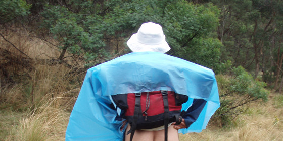
Mixed Naturist Bushwalk, Bamganie State Forest (near Meredith)
Meredith Cafe and Corner Store
10:30 – 16:00
Please Note: We are very pleased that from 23 Nov the Covid restrictions have been eased so that we now take up to a limit of 50 walkers on our Bamganie hike. However walking in a very large group can be difficult, so at this stage we are planning to walk in two goups of up to 25 each and each with a different leader. (As of Sun 22 Nov there are 20 spots left.) Looking forward to seeing you all on Sun 29th.
Enjoy a day out in the buff in a small out-of-the-way state forest not too far from Melbourne.
GRADE | LENGTH | TYPE: Moderate, approximately 7 to 8 km circuit walk.
ACTIVITY DESCRIPTION:
This walk is for naturists. Enjoy a nude day out in a small and remote state forest. There are pleasant tracks through the open forest, some 4WD tracks and some animal pads to follow, with the occasional challenge of having to cross a small creek or two. This forest is a favourite habitat of the echidna and it's quite usual to see them fossicking around for a tasty ant lunch.
After the Walk: If you feel like a cool drink or a coffee after the walk we could go to The Royal Hotel, 16 Wallace St, Meredith (COVID-19 restrictions permitting).
BOOKING: By Thursday 26th November. To register, click on Get Tickets.
MEETING TIME | LOCATION: 10:30am at the Meredith Corner Store and Cafe, 17 Wallace St, Meredith. This is on the corner of the A300 Midland Hwy.
MAP REFERENCE: Melway map X911 grid C4 | VicRoads Map 522 grid H9 | Google map goo.gl/maps/NK7PsTMqbbqk1nsX6.
DISTANCE | TIME FROM GPO: 105 km, 1 hour 30 minutes to 1 hour 40 minutes depending on the route taken.
PUBLIC TRANSPORT: There is no public transport arriving in Meredith in time on Sundays. Please email the leader who should be able to arrange a lift for you. In your email please state 1) your suburb of residence and 2) a contact phone number.
FOOD: Carry lunch, snacks and approximately 1.5 litres water.
APPAREL | FOOTWEAR: Comfortable walking boots/shoes, hat, dark glasses, sunscreen, repellent, a small towel in case there is water in the creek. A pair of shorts should be carried, but it's unlikely we'll need them.
LEADER: Russell W. | Email the Leader if you have any questions. Members can access leader contact details under Members | Leader Contacts when logged in to the website.
HOME BACK TO LIST OF EVENTS MEMBERSHIPS
Nov
22
2020
Past Event
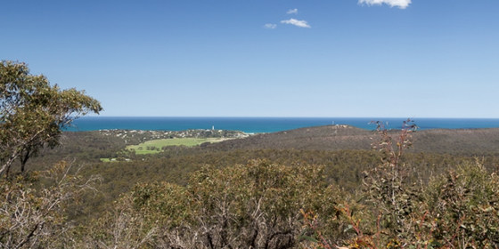
Currawong Falls, Aireys Inlet day walk
Aireys Inlet General Store
10:30 – 16:00
Spend a day in the glorious ironbark forests behind Aireys Inlet, with views over the sea. Maximum of 12 participants.
GRADE | LENGTH | TYPE: Medium 12.5 km circuit walk on formed track. It undulates, but there is no sustained climbing. The walk climbs up to 230m.
ACTIVITY DESCRIPTION:
This very scenic walk passes through rainforest, and dry forests behind Aireys Inlet. We will all meet at the General Store in Aireys inlet (on the left on the main road). From there we will drive in convoy to the start. There are no facilities during the walk, and we will have a picnic lunch along the way.
MEETING TIME | LOCATION: 10:30am at the Aireys Inlet General Store, 40 Great Ocean Rd, Aireys Inlet.
MAP REFERENCE: Melway map X911 grid C10 | Google map goo.gl/maps/Ue4ekLE1NbvK5ZqL7.
DISTANCE | TIME FROM GPO: 130 km from Melb GPO. Allow 1 hour 40 minutes to drive to the meeting point (head towards Geelong, then past Anglesea along the Great Ocean Road).
PUBLIC TRANSPORT: Not available on Sunday morning.
FOOD: Bring lunch, and also at least 1 litre of water depending on how hot the day is.
APPAREL | FOOTWEAR: Light comfortable walking footwear and dress according to the weather forecast. Check the weather forecast before leaving. It can be very hot and sunny, or quite cool and wet near the ocean.
BOOKING: By Friday 20th November. To register, click on Get Tickets.
LEADER: Roger H. / Alan D. | Email the Leader if you have any questions. Members can access leader contact details under Members | Leader Contacts when logged in to the website.
HOME BACK TO LIST OF EVENTS MEMBERSHIPS
Nov
15
2020
Past Event
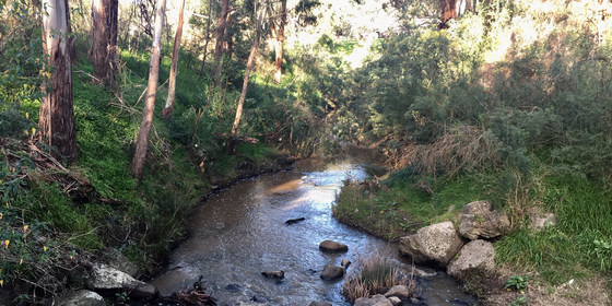
Plenty River/Yarra Trail Hike - Greensborough to Ivanhoe *New Time*
Greensborough Railway Station
10:00 – 16:00
Please note: This event has been moved forward from it's original date of Sun Oct 25th due to the ongoing Vic Government Covid-19 restrictions and regulations. The new proposed date is subject to change. Please regularly check this page for any date changes.
Enjoy a day out exploring the winding Plenty River and Yarra Trail, passing playgrounds, sport fields, reserves, natural bushland and farmland. We will cross several cute bridges as we intimately traverse a decent section of the Plenty & Yarra Rivers. The rivers are home to floodplain riparian woodlands, grassy valley forest and riparian scrub, grassy dry forest/box-stringybark woodland. Swamp wallabies, echidnas and wombats are all found in the area, along with many native birds.
GRADE | LENGTH | TYPE: A moderate 17.5 km point-to-point walk with public transport links. Mostly paved walking tracks with low to moderate gradient (70m max). (Optional exit at Heidelberg approx. 11 km into the walk is also offered, although the full length of the walk is encouraged).
ACTIVITY DESCRIPTION: (Subject to COVID-19 restrictions at the time of the event)
A great walk to get your exercise routine back in shape! The trail is varied and rather scenic as we closely hug our way around the river. Our walk commences at Greensborough Railway Station with a short stroll to meet the river. The walk along the Plenty River Trail offers a combination of urban parkland, natural bushland, and farmland to enjoy along the way. After passing through Willinda Park, Yallambie Park and Banyule Flats reserve, we say goodbye to the Plenty River and say hello to the Yarra River. Shortly afterward, we will stop for a well-deserved break and lunch at Heidelberg Park. After lunch, we then continue our exploration of the Yarra River through Yarra Flats Park, through the upmarket areas of Eaglemont, to arrive at Wilsons Reserve. Our last stop is Darebin Train Station.
FURTHER INFORMATION: www.banyule.vic.gov.au/Events-activities/Parks-reserves.
MEETING TIME | LOCATION: 10:45am sharp at Greensborough Train Station. The terminus of the walk is at Darebin Train station on the same train line. See below for transportation options.
MAP REFERENCE: Melway map 20 grid K2 | Google map: 74W5+C7 Greensborough, Victoria, Australia.
DISTANCE | TIME FROM GPO: 17 km, approximately 38 minutes by public transport or 35 minutes by car. For the return journey Hurstrbridge trains run every 20 minutes. All travel is within Myki zones 1 & 2 with weekend daily caps of $6.40 full fare, $3.20 concession and free for seniors.
TRANSPORT: Either cars or public transport can be used for this event even though the walk is one way. There are three scenarios to satisfy both drivers and public transport users.
Scenario 1: Take the train to Greensborough Station to arrive by the start time. At the end of the walk, catch the train at Darebin Station to continue your journey home.
Scenario 2: Drive to Greensborough Station, park the car by the start time. At the end of the walk, take the train back to Greensborough and collect your car.
Scenario 3: Drive to Darebin Station, park the car. Take the train to Greensborough to arrive by the start time. At the end of the walk, collect your car.
FOOD: Carry lunch and snacks for your needs throughout the day and at least 1 litre of water. There will be a cafe close to the lunch spot (if permitted to be open).
APPAREL | FOOTWEAR: Comfortable walking boots/shoes is a must, and dress according to the weather forecast.
BOOKING: By Friday 13th November. To register, click on Get Tickets. This event is limited to a maximum of 10 participants (subject to change). Obtaining a ticket from The Nomads website is essential.
LEADER: Jason T. | Email the Leader if you have any questions. Members can access leader contact details under Members | Leader Contacts when logged in to the website.
HOME BACK TO LIST OF EVENTS MEMBERSHIPS
Nov
14
2020
Past Event
Mixed Naturist Walk and Swim – Warrandyte State Park - * Sat 14 Nov *
262 Yarra St
10:30 – 16:00
** Due to difficulties for a number of people, including the leader, getting to this event because of the 25 km restriction, this walk has been rescheduled from Sunday 8 November to SATURDAY 14 November. **
Enjoy a naturist walk in a bush area close to Melbourne. There are great river views, lovely green paddocks of a deserted farm, often with lots of kangaroos, and a tree covered riverside walk. Have a swim if it's warm enough.
GRADE | LENGTH | TYPE: Medium 7 km naturist circuit walk. The track or route is fairly open all the way, with a narrower track through the forest. There is one moderate hill we will need to climb up and over so we get to the unclothed area faster.
ACTIVITY DESCRIPTION:
This walk is for naturists. We will meet at a cafe in Old Warrandyte for a coffee and to meet the others on the walk. At approximately 10:50am we will carpool to the start of the walk, this is 7 km and 10 minutes away.
The walk start is in the Warrandyte State Park at the Jumping Creek carpark, this is 1 km inside the State Park. The entrance is from Jumping Creek Rd. If driving from Warrandyte township the entrance to the carpark is 1 km past Nelson Drive on the left. If you reach Hooper Rd, you have gone 1.5 km too far.
Enjoy the freedom of walking nude in the forest, along the banks of the picturesque Yarra River, and across the open grassed areas of the Warrandyte State Park where there are generally lots of kangaroos. Have a cool off dip if you like and a good relax at our lunch stop.
After the walk: If desired we can return to Warrandyte for a cool off drink or coffee at the Grand Hotel, 110 Yarra St, Warrandyte (COVID-19 restrictions permitting).
MEETING TIME | LOCATION: 10:30am at the "River View Deli Cafe", 262-264 Yarra St, Warrandyte for coffee and registration. There is plenty of parking in the car park by the river, opposite the cafe.
MAP REFERENCE: Melway map 23 grid G11 | Google map goo.gl/maps/mHyVFk3BqhH2.
DISTANCE | TIME FROM GPO: 32 km, approximately 40 minutes drive.
TRANSPORT: There are buses arriving in Warrandyte on Sunday morning. Or otherwise contact the leader who can probably arrange a lift for you.
COST: $5, free for Nomads members.
FOOD: Carry lunch, snacks and water.
APPAREL | FOOTWEAR: Sunscreen, hat, sunglasses, repellent, small towel in case you go for a dip. Shorts will be required for the first half kilometre of the walk. Footwear with good grip, strap-on sandals/old sneakers could be handy if you'd like to walk in the river for a splash or swim. The river rocks are rounded, but a bit uncomfortable to walk on in bare feet.
BOOKING: By Wednesday 11th November. To register, click on Get Tickets.
LEADER: Russell W. | Email the Leader if you have any questions. Members can access leader contact details under Members | Leader Contacts when logged in to the website.
HOME BACK TO LIST OF EVENTS MEMBERSHIPS
Nov
10
2020
Past Event
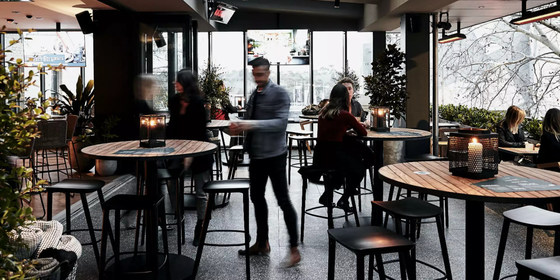
Monthly Social Night - November (online via Zoom)
20:00 – 21:30
Our regular monthly social night - online via Zoom, hopefully for the last time! The Duke of Wellington is fully booked for Tuesday night - it's still a bit tricky getting group bookings, but after this Tuesday we should be able to hold future social nights face-to-face.
ACTIVITY DESCRIPTION:
Join us for our monthly social evening where members can enjoy a meal, talk about upcoming events, compare notes on past activities and float ideas on events they would like to see run.
MEETING TIME | LOCATION: 8pm | online via Zoom. The Zoom link will be emailed on Tuesday to those who registered via Get Tickets.
BOOKING: By Monday 9th November. Click on Get Tickets to book.
LEADER: Garry O. | Email the Leader if you have any questions. Members can access leader contact details under Members | Leader Contacts when logged in to the website.
HOME BACK TO LIST OF EVENTS MEMBERSHIPS

Nov
03
2020
Past Event
Play 500 Cards with fellow Nomads - Tuesday 3 November
20:00 – 21:30
The lockdown has now eased, though options for socialising at night are still very limited. Socialising online with other Nomads is still an option - groups of four or six players per game can play 500 online - and with video and sound enabled, it's almost like being in the same room! While interest remains, we are scheduling games of 500 on Tuesdays at 8pm (except on social evening nights) using the Trickster Cards program.
If you're new to the 500 card game, but would like to learn about it, check out our 500 Cards Tutorial Notes. For some other online ideas, see Socialising Online.
TO BOOK: Click Get Tickets prior to Tuesday 3rd November so you get an invitation email on the day with your link to join the game.
TO PLAY: At 8pm on Tuesday 3rd November, click on the link in your invitation email. (Tip: schedule a notification in your phone so you don't forget)!
TROUBLE SHOOTING:
Video isn't yet available for six-handed games, though audio works, and that's all you need to have some lively table talk!
If for some reason you don't get the reminder email with the link, check your Spam or Promotions folder.
LEADER: Alan D. | Email the Leader if you have any questions. Members can access leader contact details under Members | Leader Contacts when logged in to the website.
HOME BACK TO LIST OF EVENTS MEMBERSHIPS