The Nomads Outdoors Group Inc.
Powered by
Past events
All events
Past events
Aug
31
2025
Past Event
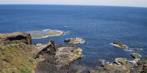
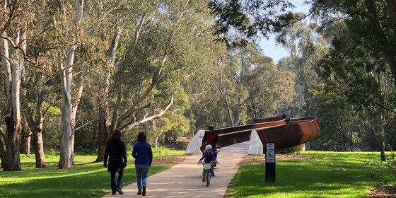
Bushrangers Bay to Cape Schanck Walk
Bushrangers Bay Walking Track
11:00 – 16:00
This is a spectacular trail skirting rugged coastline by the waters of Bass Strait.
Note: This event is an alternative to the Blind Bight Coastal Reserve Walk, which was deemed unsuitable.
GRADE | LENGTH | TYPE: Medium 13 km circuit walk.
ACTIVITY DESCRIPTION: We follow the Main Creek Trail from the car park to Bushrangers Bay. The eucalypt forest gives way to shady thickets of coastal banksia and then to an isolated sandy beach at Bushrangers Bay. From there we follow the trail to Cape Schanck. We’ll have lunch near the 1850s Lighthouse.
After lunch, we return the same way and then hopefully, time permitting, can have take away coffee and cake from the Flinders Bakehouse.
BOOKING: By Friday 29th August. To register, click on Get Tickets.
Unsure if you've already booked? Click View my bookings.
FURTHER INFORMATION: www.bushwalkingblog.com.au/cape-schanck-to-main-creek-return-mornington-peninsula-national-park-victoria-2
MEETING TIME | LOCATION: 11am at the start of the Bushrangers Bay Walk and Cape Schanck Walk. When coming from Cape Schanck, this is in the car park on the right (not the first car park on the left) on Boneo Rd (C777: the Rosebud Flinders Rd) in the Mornington Peninsula National Park.
MAP REFERENCE: Melway map 259 grid K8 | UBD map 513 grid A7 | Google map goo.gl/maps/R48zXxjF9Ty.
DISTANCE | TIME FROM GPO: 109 km from Melbourne, allow 2 hours.
FOOD: Bring your own lunch and at least 1 litre of water.
APPAREL | FOOTWEAR: Sturdy walking footwear, dress for the weather forecast and bring a raincoat just in case!
LEADER: Richard C. | Email LeaderRichardC@nomads.org.au if you have any questions.
Members can access leader contact details under Members | Leader Contacts when logged in to the website.
HOME BACK TO LIST OF EVENTS MEMBERSHIPS
Aug
24
2025
Past Event
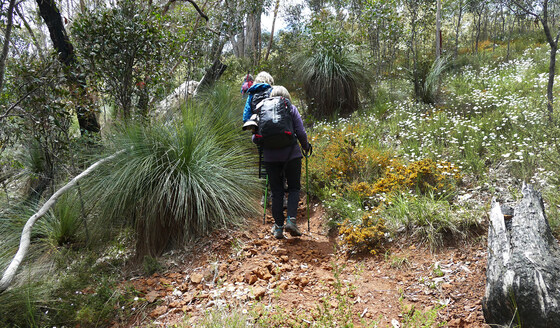
Brisbane Ranges - Ted Errey Circuit
Anakie Gorge Picnic Area
10:00 – 16:00
The circuit involves a small twisting gorge, a historic reservoir and four scenic lookouts.
GRADE | LENGTH | TYPE: Grade 4: Hard 11 km circuit walk (graded according to the AWTGS: Australian Walking Tracks Grading System). Generally on good tracks but with some steep sections, river crossings and some sections with loose gravel. 4 hour circuit walk.
ACTIVITY DESCRIPTION: Little more than an hour's drive from Melbourne takes you to the state's richest wildflower habitat. Set in a low range of mountains dissected by rocky gullies, the unusual geology of the Brisbane Ranges National Park has preserved plants that have long since vanished from other parts of the region.
The walk follows a circuit ending back at the meeting point. We will have a picnic lunch on the way.
BOOKING: By Thursday 21st August, or ASAP to ensure you don't miss out. To register click on Get Tickets.
Unsure if you've already booked? Click View my bookings.
FURTHER INFORMATION: www.parks.vic.gov.au/places-to-see/parks/brisbane-ranges-national-park.
MEETING TIME | LOCATION: 10am at the Anakie Gorge Picnic Area. Follow the Western Freeway to Bacchus Marsh and then follow the Geelong Road (C704) south for 27 km. Turn right into Granite Rd and follow it to the end to Staughton Vale Rd. Turn right and after 2 km, turn left into Gorge Rd and continue to the Anakie Gorge picnic area.
MAP REFERENCE: Google map goo.gl/maps/zriEJwpmpXktFauCA.
DISTANCE | TIME FROM GPO: 83 km | 1 hour 10 minutes.
FOOD: Bring lunch, snacks and water. No shops on the way.
APPAREL | FOOTWEAR: Dress for the occasion. Bring warm clothing if needed and certainly bring wet weather gear in case inclement weather is forecast. Sunscreen, sunglasses and hat may be needed (unlikely). Sturdy walking footwear and a pole if you are used to one, since there is one slippery hill.
LEADER: Roger H. | Email LeaderRogerH@nomads.org.au if you have any questions.
Members can access leader contact details under Members | Leader Contacts when logged in to the website.
Image: www.parks.vic.gov.au
HOME BACK TO LIST OF EVENTS MEMBERSHIPS
Aug
17
2025
Past Event
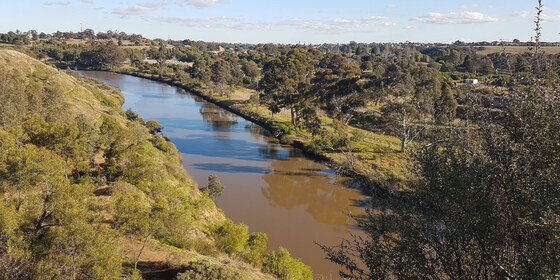
Maribyrnong River Walk + Anglers Tavern Lunch
Footscray Station
10:30 – 16:00
Enjoy a stroll beside the Maribyrnong River with lunch at the Anglers Tavern, optionally followed by a more strenuous but very scenic hike further upstream. Travel via public transport is recommended.
GRADE | LENGTH | TYPE: Grade 2: Easy approximately 6 km walk to lunch, or Grade 3: Moderate 13.5 km
(graded according to the AWTGS: Australian Walking Tracks Grading System), point-to-point walk on mostly flat paths, with some gentle climbs for those continuing after lunch.
ACTIVITY DESCRIPTION: Starting from Footscray Station, we'll head to the Maribyrnong River via Newells Paddock Wetlands. From there we walk upstream beside the river past Flemington Racecourse, through assorted parks and wetlands for lunch at the Anglers Tavern, 2 Anglers Way, Maribyrnong. After lunch you can catch a tram nearby on Maribyrnong Rd, or continue with the group to Lily Reserve, for some great views of Melbourne's skyline. After that we follow Steele Creek and the Maribyrnong River around to Canning Reserve. From nearby you can catch the #57 tram to the CBD or walk a tad further to catch the #82 tram to take you back to Footscray Station or towards Moonee Ponds.
BOOKING: By Friday 15th August. To register, click on Get Tickets.
Unsure if you've already booked? Click View my bookings.
MORE INFO: Maribyrnong: Footscray to Canning Reserve: some history of the region the walk passes through.
MEETING TIME | LOCATION: 10:30am at the main exit of Footscray Station (the western exit) - we'll meet beside the bus stop directly opposite the Footscray Market.
MAP REFERENCE:
Starting Point - Google map: goo.gl/maps/mtqJSKcQsgqV7FzH8.
The Route: Footscray Station to Canning Reserve via Maribyrnong River.
PUBLIC TRANSPORT:
The Williamstown line train that departs Flinders Street Station platform 10 at 10:07am arrives at Footscray Station at 10:19am. The #82 tram that departs from Moonee Ponds Junction at 9:56am terminates at Footscray Station at 10:25am.
Note: There will be bus replacements on the Werribee line, but the Williamstown line and V/Line trains can still be used.
For other options see ptv.vic.gov.au.
FOOD: Lunch will be ordered at the Anglers Tavern. A small water bottle is recommended - there are some refill points along the way.
APPAREL | FOOTWEAR: Comfortable walking boots/shoes and dress according to the weather forecast.
LEADER: Alan D. | Email LeaderAlanD@nomads.org.au if you have any questions.
Members can access leader contact details under Members | Leader Contacts when logged in to the website.
HOME BACK TO LIST OF EVENTS MEMBERSHIPS
Aug
10
2025
Past Event
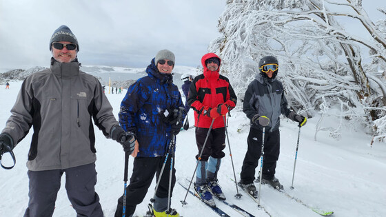
Ski Week at Falls Creek
Cosela Alpine Club
10 Aug 2025 13:00 – 17 Aug 2025 10:00
A full week of cross-country skiing, downhill skiing and/or snowboarding, staying in a cosy lodge at Falls Creek. Stay the full week, or part thereof.
GRADE | LENGTH | TYPE: Your choice (choose slopes and equipment to match your skills) – cross-country skiing, downhill skiing and/or snowboarding.
ACTIVITY DESCRIPTION: A full week (or part thereof) ski trip to Falls Creek is planned for a week Sunday 10th to Sunday 17th August. We will be staying at the cosy Cosela Alpine Lodge, which provides ski-in ski-out access from Wombats Ramble with no oversnow transport requirements. This will be a cross-country ski, downhill ski and/or snowboard week leaving Melbourne on Sunday and leaving Falls Creek the following Sunday.
BOOKING: Please get a Nomads ticket ASAP by clicking on Get Tickets, as there are limited beds now available. It's advisable to email LeaderLesB@nomads.org.au after you book, so he can advise what beds are available and organise payment.
Unsure if you've already booked? Click View my bookings.
FURTHER INFORMATION: www.cosela.com.au/Winter/index.html.
MEETING TIME | LOCATION: Sunday afternoon, Cosela Alpine Lodge, Falls Creek.
MAP REFERENCE: Melway Map X922 grid H10 | Google map goo.gl/maps/V7fBUEiNBb62.
GETTING THERE: There are coach services from Melbourne, Mt Beauty and many other locations to Falls Creek. There are long-term parking facilities in Mt Beauty if you don’t wish to take your car up the mountain. If driving, take the Hume Freeway (M31) to Wangaratta then the Great Alpine Road (B500), turning off to Mt Beauty. On arrival at Falls Creek you should request to unload your luggage at the steps beyond the CFA station, which is lit at night. As you are staying at Cosela, you don't need oversnow transport. After unloading, you will return to the attendant to be directed to a parking place. Cosela Lodge can then be reached by travelling up the steps and across Snowgum Lane (see map at www.cosela.com.au/Winter/Map.html).
DISTANCE | TIME FROM GPO: 391 km, 4.5 hours.
FOOD: It's advisable to bring food for the period of your stay; group catering arrangements will be organised after registration. Breakfast cereal, milk, bread, jam, condiments, tea and coffee are provided by the lodge. There’s a local food store for last minute supplies and oversights.
COSTS: You can come for the full period or part thereof:
ACCOMMODATION MON-THU: The accommodation cost is $125 per Nomads member per night.
ACCOMMODATION FRI-SAT: $280 for Friday plus Saturday night (i.e. $140 per night, but payment is required for both nights if either is required).
BOOKING FEE: There is also a $3.50 service booking fee.
BUS - MOUNT BEAUTY TO FALLS CREEK: The bus fee is $79 Mount Beauty to Falls Creek return if you decide to park in Mt Beauty bus depot a secure parking fee of $84 for the 7 nights.
FALLS CREEK PARKING: The parking fee at Falls Creek is $469 for the 7 nights (plus you will need to carry snow chains).
NON MEMBERS: Not a Nomads member? Purchase a temporary one-month membership before getting your tickets (cost $8).
APPAREL | FOOTWEAR: Bring sheets and pillowcases, towel, washer and toiletries, plus ski gear to suit all possible conditions (or hire it in Mt Beauty or Falls Creek). Don’t forget warm, comfortable clothing for after-ski activities. If driving you will be required to carry chains (these can be hired in Mt Beauty), and you should ensure your radiator has antifreeze.
LEADER: Les B. | Email LeaderLesB@nomads.org.au if you have any questions.
Members can access leader contact details under Members | Leader Contacts when logged in to the website.
HOME BACK TO LIST OF EVENTS MEMBERSHIPS
Aug
10
2025
Past Event
Kew To Alphington Parklands Tour
Boroondara General Cemetery
10:30 – 16:00
Explore memorials to love, gay and straight, in the Boroondara General Cemetery then traverse a series of connected parklands, finishing at Alphington Railway Station.
GRADE | LENGTH | TYPE: Grade 2: Easy 7 km point-to-point walk (graded according to the AWTGS: Australian Walking Tracks Grading System).
ACTIVITY DESCRIPTION: This point-to-point walk starts with a tour of the historic garden style cemetery where we will inspect memorials to love. The cemetery is noted for its outstanding collection of memorials. Departing the cemetery, the walk will continue through a series of connected parklands to our destination of Alphington Railway Station. The parklands include Victoria Park, Hyde Park, Willsmere-Chandler Park, Kew Billabong, then past golf courses as we cross the Yarra River and enter Napier Waller Reserve followed by Sparks Reserve and finally into Darebin Parklands. We’ll have lunch overlooking the banks of the Yarra River. Travel via public transport is recommended.
Land for the historic 13 hectare Boroondara Cemetery was set aside in 1855 with the first burial taking place in March 1859. The cemetery is laid out in the Victorian garden style with burials allocated by the then practice of religious denomination.
BOOKING: By Thursday 7th August. To register, click on Get Tickets.
Unsure if you've already booked? Click View my bookings.
FURTHER INFORMATION: www.kewcemetery.com.au
MEETING TIME | LOCATION: 10:30am at the entrance to Boroondara Cemetery.
MAP REFERENCE: Melway map 45 grid E5 | Google maps goo.gl/maps/vTifVjAfmaFGoBFb7.
DISTANCE | TIME FROM GPO: 8 km, approximately 20 minutes to drive, 30 minutes by public transport.
PUBLIC TRANSPORT: Tram #48 - North Balwyn to stop #36 - Parkhill Road. Alternatives are Trams #16 and #109 to the corner of Cotham and Glenferrie Roads then walk along Mary Street (550 metres - 7 minutes).
FOOD: Carry lunch, snacks and at least 1 litre of water, refills plus access to toilets available along the route.
APPAREL | FOOTWEAR: Comfortable walking boots/shoes and dress according to the weather forecast.
LEADER: Garry Oliver. | Email LeaderGarryO@nomads.org.au if you have any questions.
Members can access leader contact details under Members | Leader Contacts when logged in to the website.
HOME BACK TO LIST OF EVENTS MEMBERSHIPS
Aug
05
2025
Past Event
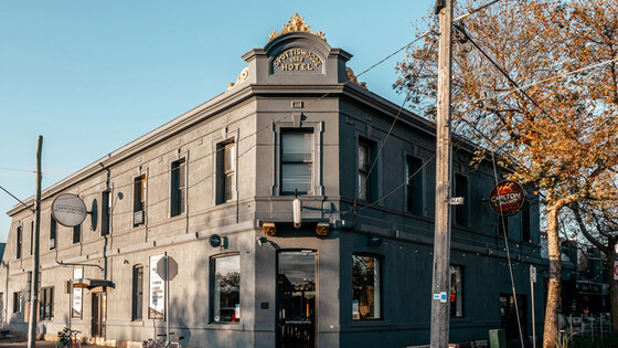
Monthly Social Night - Spotswood Hotel
Spotswood Hotel
19:00 – 21:00
Our regular monthly social night - this month at Spotswood Hotel.
GRADE: Social.
ACTIVITY DESCRIPTION: Join us for our monthly social evening where members can enjoy a meal, talk about upcoming events, compare notes on past activities and float ideas on events they would like to see run. Do you want to see more of a particular activity, or do you have a particularly favourite area of Victoria you would like to share with others? Do you have an idea for a walk we haven't done before? If so, we'd love to hear from you. Everyone is welcome – new members are especially invited to any of the monthly Nomads social evenings.
Tuesday night is Burger Night at Spotswood Hotel: free drink + fish/chicken/beef/vegan burger for $25. See menu.
BOOKING: By Sunday 3rd August. To register, click on Get Tickets.
Unsure if you've already booked? Click View my bookings.
MEETING TIME | LOCATION: 7pm at Spotswood Hotel, 62 Hudsons Rd, Spotswood.
MAP REFERENCE: Google map maps.app.goo.gl/AZLHg5XEob5ApP3x7.
PUBLIC TRANSPORT: Catch a Werribee or Williamstown line train to Spotswood Station.
LEADER: Garry O. | Email LeaderGarryO@nomads.org.au if you have any questions.
Members can access leader contact details under Members | Leader Contacts when logged in to the website.
HOME BACK TO LIST OF EVENTS MEMBERSHIPS
Jul
27
2025
Past Event
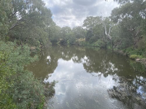
Werribee River Circuit Walk - CANCELLED
Werribee Station
11:00 – 15:00
CANCELLED. Buses replace trrains on the Werribee line. It appears you'd have to take the Geelong train to Tarneit, and transfer to a bus. This means that instead of a 50 minute train trip, it'd almost double
A circuit walk in the west of Melbourne, from Werribee Station.
GRADE | LENGTH | TYPE: Grade 2: Easy 7 km circuit walk (graded according to the AWTGS: Australian Walking Tracks Grading System).
ACTIVITY DESCRIPTION: This easy and pleasant walk loops around the Werribee River. It is an easy, paved path with hardly any elevation, and it's a beautiful track, considering it passes through suburbia.
Generally considered an easy route, it is a popular trail for hiking, running, and walking. The trail is open year-round and is beautiful to visit anytime. There are three spots where you can cross the river by jumping across big rocks, perfect for exploring. You can continue north and south on this track for a longer route.
BOOKING: By Friday 25th July. To register, click on Get Tickets.
Unsure if you've already booked? Click View my bookings.
MEETING TIME | LOCATION: 11am at southern side of Werribee Station. This is on Station Place at the top of the ramp.
PUBLIC TRANSPORT: Take a Werribee train from Flinders Station at 9:47am, or 10:07 absolute latest. Go to first carriage.
MAP REFERENCE: Google map: maps.app.goo.gl/Khz7KwjjYoFkVZYZ8
FOOD: Carry lunch, snacks and a litre of water. As it's a short walk, we will have a late lunch or afternoon tea in Werribee after walk.
APPAREL | FOOTWEAR: Comfortable walking boots and dress according to the weather forecast.
LEADER: Richard C. | Email LeaderRichardC@nomads.org.au if you have any questions.
Members can access leader contact details under Members | Leader Contacts when logged in to the website.
HOME BACK TO LIST OF EVENTS MEMBERSHIPS
Jul
16
2025
Past Event
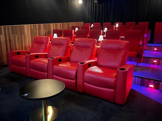
Dinner & 'PRIDE' Movie Night in Brunswick
Henkel Street Cinema
18:00 – 21:15
** This event has sold out. **
We've booked out Cinema 1 of the Henkel Street Cinema in Brunswick, so you can optionally have a quick pub meal nearby, then watch the movie Pride (2014) surrounded by your Nomads friends.
GRADE: Social.
ACTIVITY DESCRIPTION: You can either join us at 6pm at the Hotel Railway Brunswick, 291-293 Albert St for a pub meal, or come directly to the Henkel Street Cinema, 10/102 Henkel St, Brunswick at 7pm in readiness for the screening to start at 7:15pm.
Wednesday is parma night at the pub - chicken or eggplant parma with fries and slaw for $20 - or you can order from their pub menu.
For the cinema, you can pre-order food and drinks online, order at the bar upon arrival at the cinema, or order via a QR code near your (comfortable) seat. Available options include cinema snacks (popcorn, choc tops and sweets), vegetarian pizza, arancini balls, beer, wine, cider and soft drinks.
Pride is a movie based on a true story that depicts a group of lesbian and gay activists who raised money to help families affected by the British miners' strike in 1984, at the outset of what would become the Lesbians and Gays Support the Miners campaign. The activists decide to ignore the Union and go direct to the miners. Almost by accident, a minibus-load of gays find themselves in the Welsh village of Onllwyn in the Dulais valley, and through their sincere fundraising and Jonathan's nifty disco moves, persuade most of the community that they are on the same side.
BOOKING: By Tuesday 15th July or ASAP to ensure you don't miss out (only 22 seats available). To register click on Get Tickets and indicate whether you're planning to attend the pub or just the cinema.
Unsure if you've already booked? Click View my bookings.
MEETING TIME | LOCATION: Either:
6pm at the Hotel Railway Brunswick, 291-293 Albert St, Brunswick to dine with us prior to the film, or
7pm at the Henkel Street Cinema, 10/102 Henkel St, Brunswick
Both venues are located close to the Brunswick train station.
MAP REFERENCE:
Hotel Railway Brunswick Google map: maps.app.goo.gl/epMzaYCY38dx7XcM7.
Henkel Street Cinema Google map: maps.app.goo.gl/uVUXzSXGLBT8ReE49.
PUBLIC TRANSPORT:
Train: Upfield line to Brunswick
Tram: 19 to stop 22 (Albert St/Sydney Rd)
FOOD: Dinner can be purchased at the Hotel Railway Brunswick | Snacks and drinks can be purchased at the Henkel Street Cinema.
LEADER: Colin C. | Email LeaderColinC@nomads.org.au if you have any questions.
Members can access leader contact details under Members | Leader Contacts when logged in to the website.
HOME BACK TO LIST OF EVENTS MEMBERSHIPS
Jul
12
2025
Past Event
Short Winter Yarra River circuit ramble from Fed Square
11:00 – 15:00
A very pleasant and relatively short circuit ramble from Federation Square up the Yarra River, with picnic lunch at Como Park or cafe lunch at Kanteen Cafe before a leisurely walk back to the CBD for an optional social drink.
GRADE | LENGTH | TYPE: Grade 2: Moderate 10.9 km circuit walk (graded according to the AWTGS: Australian Walking Tracks Grading System) on flat well formed shared cycleway/footpaths. If opting for a picnic lunch at Como Park, use of the pedestrian crossing is strongly recommended to cross busy Alexandra Ave from the Kanteen Cafe to Como Park.
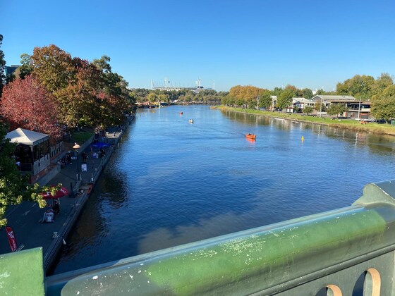
ACTIVITY DESCRIPTION: Meeting below Federation Square/Birrarung Marr (beside the path that runs from Swanston Street towards the MCG), a very pleasant and relatively short ramble from Federation Square up the Yarra River, taking in the sights, smells, wild-life and river activities, upstream as far as the MacRobertson Bridge, before crossing to walk city-bound on the opposite bank, stopping for an optional cafe lunch at Kanteen Cafe (see map) or a picnic lunch at Como Park on the opposite side of Alexandra Ave, before walking back to the CBD for an optional well earned post-walk drink opposite Flinders Street Station.
BOOKING: By Friday 11th July. To register click on Get Tickets.
Unsure if you've already booked? Click View my bookings.
MEETING TIME | LOCATION: 11am at Federation Square/Birrarung Marr beside the bike parking hoops on the path that runs from Swanston St towards the MCG. This is the intermediate level, below the main Federation Square and above the river level. There are toilets nearby.
MAP REFERENCE: Google map maps.app.goo.gl/7K8VwsWEGaCHTcVB7.
PUBLIC TRANSPORT: Use of trains/trams to Flinders Street Station is recommended. The meeting point is a couple of hundred metres from Flinders Street Station.
FOOD: Carry snacks and a litre of water. You can bring a picnic lunch or purchase lunch from the Kanteen Cafe.
APPAREL | FOOTWEAR: Comfortable walking boots/shoes and dress according to the weather forecast.
LEADER: MichaelC. | Email LeaderMichaelC@nomads.org.au if you have any questions.
Members can access leader contact details under Members | Leader Contacts when logged in to the website.
HOME BACK TO LIST OF EVENTS MEMBERSHIPS
Jul
06
2025
Past Event
Sherbrooke Forest Walk
Belgrave
11:00 – 16:00
Enjoy a stroll through the Sherbrooke Forest, always a magical experience, even if it's raining!
GRADE | LENGTH | TYPE: Grade 3: Moderate 9.5 km circuit walk, mostly on forest dirt tracks, including some steep climbs (graded according to the AWTGS: Australian Walking Tracks Grading System). Be sure to wear boots or heavy walking shoes as the tracks can be muddy and slippery.
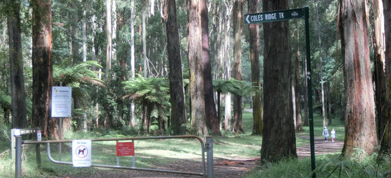
ACTIVITY DESCRIPTION: A round trip making use of public transport, meeting at Belgrave Metro railway station and walking through Sherbrooke Forest. Our route will probably take in the Sherbrooke Falls, George Tindale Memorial Gardens, Coles Ridge Track and Grants Picnic Ground. We'll probably have a picnic lunch in the grounds of the George Tindale Memorial Gardens. There will be time available for drinks after the walk. Trains depart from Belgrave, bound for Flinders Street, every twenty minutes.
BOOKING: By Friday 4th July. To register click on Get Tickets.
Unsure if you've already booked? Click View my bookings.
MEETING TIME | LOCATION: 11am at the Belgrave Metro Railway Station (not the Puffing Billy Station).
MAP REFERENCE: Melway map 75 grid F10 | Google map goo.gl/maps/yGEKdTXm1bUCJww76 | Approximate route map: Sherbrooke Forest Circuit via George Tindale Gardens.
PUBLIC TRANSPORT: Catch the Belgrave line train that departs Flinders St platform 2 at 09:26am, arriving at Belgrave at 10:52am. For the return trip, trains depart from Belgrave every 20 minutes (e.g. at 2:02pm, 2:22pm, 2:42pm, 3:02pm etc).
FOOD: Carry lunch, snacks and a litre of water.
APPAREL | FOOTWEAR: Comfortable walking boots/shoes and dress according to the weather forecast. It will be cooler, and potentially wetter, in the Dandenongs than in central Melbourne.
LEADER: Alan D. | Email LeaderAlanD@nomads.org.au if you have any questions.
Members can access leader contact details under Members | Leader Contacts when logged in to the website.
HOME BACK TO LIST OF EVENTS MEMBERSHIPS
Jul
01
2025
Past Event
Monthly Social Night - The General Assembly (South Wharf)
The General Assembly
19:00 – 21:00
Our regular monthly social night - this month at The General Assembly, South Wharf.
GRADE: Social.
ACTIVITY DESCRIPTION: Join us for our monthly social evening where members can enjoy a meal, talk about upcoming events, compare notes on past activities and float ideas on events they would like to see run. Do you want to see more of a particular activity, or do you have a particularly favourite area of Victoria you would like to share with others? Do you have an idea for a walk we haven't done before? If so, we'd love to hear from you. Everyone is welcome – new members are especially invited to any of the monthly Nomads social evenings.
See The General Assembly website for more details, including their menu.
BOOKING: By Monday 30th June. To register, click on Get Tickets.
Unsure if you've already booked? Click View my bookings.
MEETING TIME | LOCATION: 7pm at The General Assembly, 29 South Wharf Promenade, South Wharf.
MAP REFERENCE: Google map maps.app.goo.gl/Mu61ZPNZ4Pijbaiz5.
PUBLIC TRANSPORT: The General Assembly is a 14 minute walk from Southern Cross Station (or 19 minutes from Flinders Street Station). Alternatively, take tram 12, 96 or 109 to stop 124A (Casino/MCEC/Clarendon St).
LEADER: Richard C. | Email LeaderRichardC@nomads.org.au if you have any questions.
Members can access leader contact details under Members | Leader Contacts when logged in to the website.
HOME BACK TO LIST OF EVENTS MEMBERSHIPS

Jun
30
2025
Past Event
Spring Program Pre-planning - Online via Zoom
19:00 – 20:00
Preparing the draft Spring program of events - online via Zoom.
GRADE: Social.
ACTIVITY DESCRIPTION: The bulk of the planning for the upcoming Spring program will be done in this pre-planning meeting via Zoom in readiness to present the draft program the next night at the Social Evening, where attendees will be invited to provide additional suggestions and help fill any gaps.
BOOKING: By 5pm Monday 30th June. To register, click on Get Tickets. Alternatively, simply click on the Zoom link in the reminder email sent to members a few days prior to the event.
Unsure if you've already booked? Click View my bookings.
DRAFT PROGRAM: Nomads Draft Program. You may add your suggestions to this online spreadsheet - be sure to click to some other cell once you've finished, so that your suggestion gets saved.
MEETING TIME | LOCATION: 7pm online via Zoom. Those who registered will be sent the Zoom link by 6pm on Monday evening.
LEADER: Alan D. | Email LeaderAlanD@nomads.org.au if you have any questions.
Members can access leader contact details under Members | Leader Contacts when logged in to the website.
Photo by Bich Tran from Pexels.
HOME BACK TO LIST OF EVENTS MEMBERSHIPS