

The Nomads Outdoors Group Inc.
Powered by

** Nomads email addresses have changed to the format LeaderFredN@nomads.org.au, and may go into your Junk Folder as a result. See Some Recommendations about Nomads Emails to prevent that **
The Nomads is a social outdoors group for gay and gay-friendly men of all ages. It also welcomes those from the lesbian, bisexual and transgender communities, and anyone who shares its objectives of tolerance and acceptance.
 Check out the upcoming Nomads events
 If you don't receive a confirmation email, check your Spam folder!
  Check your currently active bookings (login required)
The Nomads would like to acknowledge the traditional custodians of the lands on which we meet for our events, and we pay our respects to Elders past and present.
Events
View all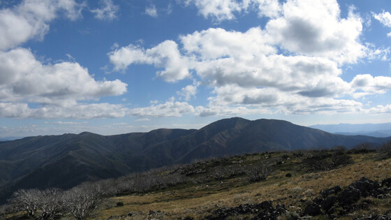
Oct
30
Bogong High Plains Walking - accommodation at Falls Creek
Cosela Alpine Club
30 Oct 2026 15:00 – 03 Nov 2026 16:00
** Accommodation is tight, please get a Waiting List ticket and indicate exactly your preferences. We will actively try to make it happen. **
The event is a mixed social and bushwalking event, based on accommodation at Cosela Alpine Lodge and walks on the Bogong High Plains. We have booked out the Cosela Alpine Club in Falls Creek for four nights over the 2026 Melbourne Cup weekend and will do day walks on the Bogong High Plains from that base.
GRADE | LENGTH | TYPE: Various. The walks will be selected based on the weather forecast plus the abilities and wishes of the attendees. It will also be possible to do easier self-guided walks closer to the Falls Creek village.
WALK OPTIONS: There are a great number of walks available in this very special region. The walks actually selected will depend on the weather forecast plus the abilities and wishes of the attendees. The following links give some examples, but there are many available options:
Victoria's High Country: The High Country - Walks around Bogong High Plains and Mountain Creek.
AllTrails: Bogong High Plains Loop.
AllTrails: Best Trails in Bogong.
ACCOMMODATION: We have booked out the entire Cosela Alpine Lodge. The lodge is centrally located in the Falls Creek Village. (In winter it provides ski-in, ski-out access to the snow fields).
The deal is for Friday + Saturday + Sunday + Monday nights (i.e. four nights). If not present for part of the period, you still need to pay for the full period.
There are two standards of accommodation: Standard Rooms (with shared bathrooms) and Premium Rooms (each with an ensuite bathroom). There will be a 20% surcharge for Premium Rooms.
The cost for a queen bed is double the cost for a single bed/bunk.
All attendees need to bring their own sheets, pillowcase and towel.
The bed cost will depend on the number of attendees - the more attending, the cheaper the cost for everybody.
BED COST: STANDARD Single Bed: $205 | PREMIUM Single Bed: $245 | STANDARD QUEEN bed: $410 | PREMIUM QUEEN bed: $490.
In rooms with single beds, two beds can be pushed together to form a double bed.
The room quality varies somewhat. Rooms will be allocated on a best-available basis in the order that bookings are received (for the requested room type).
Above Photo: Communal area in Cosela Lodge.
The Lodge has room duties that need to be completed every day so the lodge is kept clean and tidy. So be prepared to clean bathrooms, vacuum, sweep and mop floors. Those that choose an ensuite room only need to clean their own bathroom before leaving.
BOOKING: To join this weekend you need to book ASAP by clicking Get Tickets. Places will be allocated in the order of registration. Cancellations within a month of the event will only receive a refund if somebody else is able to take your place. If you find the event is fully booked, please take out a free WAITING LIST ticket and you will be contacted (in the order of ticketing) if a bed becomes available. This event is not open to Visitors (but Visitors can take out a 1-month membership, cost $8, prior to booking).
Unsure if you've already booked? Click View my bookings.
Booking Guide: When booking, you will be asked the following questions:
Optional: Name of the PARTNER you wish to share a BED with? You will only be asked this if booking a Queen bed.
Further details about what you want? You can use this free text field to make any special requests. For example, you might list the people, other than a named partner, who you wish to share your room with; or you might request a private room with your partner.
Dietary Needs. You will be asked to select from the available options to assist with planning, so that attendees can be grouped into appropriate food teams.
How are you travelling to the event? & My Suburb: Please select the appropriate option so that we can maximise car pooling.
SAFETY POINTS:
APPAREL: Walkers must carry enough clothing and gear for all weather eventualities irrespective of the starting weather and forecast, as mountain weather can change very rapidly; you should wear comfortable walking boots or shoes and carry a minimum of a sun hat, a warm hat and a rain and wind proof jacket.
BRIEFING: A briefing will be given each day about the planned walks.
FOOD & MEALS: There are very limited options for purchasing food in the Falls Creek Village in summer, so it is essential for us to bring all food and drink needs with us. Due to the limited kitchen space, the attendees will be divided into four teams, with each team providing a three-course meal on one of the four evenings. The ingredients for the evening meals will be organised collectively, but bring your own breakfasts, lunches, drinks and snacks for all days. During the walks it is essential you carry your own lunch, snacks and at least 1 litre of water.
MEETING TIME | LOCATION: Arrival time is from 3pm Friday onwards at Cosela Alpine Lodge, 5 Snowgum Lane, Falls Creek.
MAP REFERENCE: Google map goo.gl/maps/V7fBUEiNBb62.
DISTANCE | TIME FROM GPO: 391 km, 4.5 hours.
GETTING THERE: To drive from Melbourne, take the Hume Freeway (M31) to Wangaratta then the Great Alpine Road (B500), turning off to Mt Beauty. There are train/coach services from Melbourne to Mt Beauty, but in summer the options for getting from Mt Beauty up the mountain to Falls Creek are very limited.
LEADER: Les B. and Stephan C. | Email LeaderLesB@nomads.org.au or LeaderStephanC@nomads.org.au if you have any questions.
Members can access leader contact details under Members | Leader Contacts when logged in to the website.
HOME BACK TO LIST OF EVENTS MEMBERSHIPS
Nov
10
November Social Night - Junction Club, Moonee Ponds
Junction Club
19:00 – 21:00
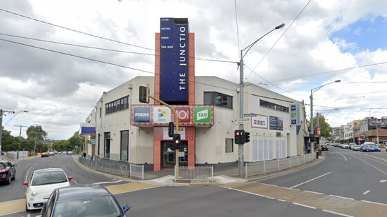
Our regular monthly social night - this month at the Junction Club in Moonee Ponds.
GRADE: Social.
ACTIVITY DESCRIPTION: The Nomads hold a social night each month, where members and guests can enjoy a meal, talk about upcoming events, compare notes on past activities and float ideas on events they would like to see run. Everyone is welcome to these monthly Nomads social evenings.
Tuesday night is Lasange night at $20 plus pot of beer or house wine for $5. See the Junction Club Menu (scroll down) for other options. They also have a seniors menu.
BOOKING: By Sunday 8th November. To register, click on Get Tickets.
Unsure whether you've booked already? Click View my bookings.
MEETING TIME | LOCATION: 7pm at the Junction Club, 740 Mount Alexander Rd, Moonee Ponds.
MAP REFERENCE: Google map maps.app.goo.gl/VmZhjqUhFnbjMKWQ9.
PUBLIC TRANSPORT: Take tram #59 (Flinders Street Station to Airport West) to stop 32. Alternatively, the Junction Club is a 640m walk from Moonee Ponds Station, on the Craigieburn line.
LEADER: Paul K | Email LeaderPaulK@nomads.org.au if you have any questions.
Members can access leader contact details under Members | Leader Contacts when logged in to the website.
HOME BACK TO LIST OF EVENTS MEMBERSHIPS
Nov
14
Mt Dandenong Hike - Kalorama to Silvan Reservoir and Olinda
Croydon Railway Station/Railway Grove
10:00 – 17:00
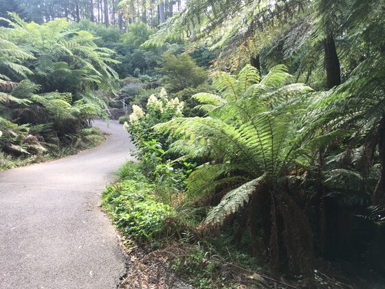
Escape the city and enjoy a full-day autumn hike through the picturesque Dandenong Ranges, taking in the lush scenic forest, birds, walking tracks, reservoir and crisp/fresh air. This event caters for the experienced/ fit hiker who demands a 'real hike' and wants to break out a sweat. This event is graded Grade 4 'hard' with a number of steep short inclines during the second part of the hike.
This event is not suitable for first timers or those with limited fitness abilities. If in doubt, contact the leader prior to booking to discuss your fitness levels/suitability for the hike.
GRADE | LENGTH | TYPE: Grade 4: Hard (in limited sections), approximately 13.5 km, this event caters for experienced hikers and those with fitness levels that are able to climb short steep tracks and terrain (graded according to the AWTGS: Australian Walking Tracks Grading System).
ACTIVITY DESCRIPTION: We will meet at Croydon Station before boarding a bus for our first section of the hike at Kalorama.
Part 1: Kalorama GPO to Silvan Reservoir Lookout - Downward descent through the forest 400m to 300m elevation. (3.2 km)
Part 2: Explore the Silvan Reservoir walking along the west side enjoying the views and stop for lunch. (Flat elevation) (5.11 km)
Part 3: Start our ascent making our way to the Olinda township 300m to 560m elevation (4.84 km). At the end of the walk, we will explore the township and enjoy tea/coffee and afternoon tea. From here we will head back to Croydon Bus Station.
This is intended to be a public transport friendly event where the start and end points will be accessible by train. There is no carpooling for this event, however, you may organise your own lift with fellow walkers if you wish.
BOOKING: By Thursday 12th November. To register, click on Get Tickets.
Unsure if you've booked already? Click View my bookings (log in required).
FURTHER INFORMATION: Silvan Reservoir Park
MEETING TIME | LOCATION: 10am at Croydon Train Station, Railway Grove. Exact meetup points will be provided prior to the event by email.
MAP REFERENCE: Google map goo.gl/maps/LhvezYQ8CpHcSDoy7.
DISTANCE | TIME FROM GPO: 35 km, approximately 35 minutes to drive, 50 minutes by public transport. There is car parking available at the train station for those who wish to drive. We will all take the bus to the starting point regardless of whether you drive to the meeting spot or not. You will need a Myki card for this event.
PUBLIC TRANSPORT: This is a public transport friendly event.
By Train: Catch the Belgrave line train departing Flinders Street Station at 8:46am, or Richmond at 8:59am, then change in Ringwood to the Lilydale line train that will be waiting on the other side of the platform, which will arrive in Croydon at 9:47am. We will then catch the #688 bus to the starting point as a group. At the conclusion of the walk, the same bus will take us back to Croydon, with a connecting train back to the CBD.
FOOD/DRINKS: Carry lunch, snacks and at least 1-2 litres of water. Also bring sunscreen and a hat. Bring your Myki card for the return trip by train/bus. There will not be an opportunity to buy food and drinks during the walk. We will stop for late afternoon tea at the conclusion of the walk.
APPAREL | FOOTWEAR: Suitable boots/hiking shoes and dress according to the weather forecast (layering). The mountains are usually a few degrees cooler but you will quickly warm up as you begin the hike! Ensure your shoes are waterproof as some of the paths most likely will be a little wet/muddy and a bit slippery if it has rained heavily prior to the event. Your boots will get some dirt/mud on them!
LEADER: Jason T. | Email LeaderJasonT.@nomads.org.au if you have any questions.
Members can access leader contact details under Members | Leader Contacts when logged in to the website.
HOME BACK TO LIST OF EVENTS MEMBERSHIPS
